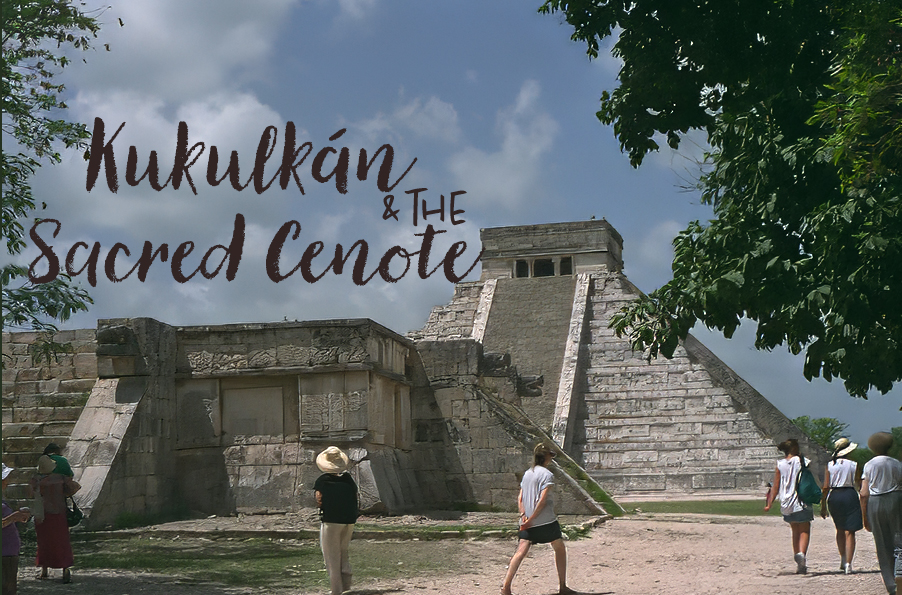
Photo of the Venus Platform & The Pyramid of Kukulkan at Chichén Itzá. If you missed any of the earlier newsletters on El Mirador, Calakmul, Río Bec, or the Puuc Hills, they are available online in the Insights Archive. Photo by B. McKenzie.
KUKULCÁN & THE CENOTES OF CHICHÉN ITZÁ
The Northern Plains area of Mexico around Chichén Itzá is a flat and low limestone shelf where the subterranean water table is relatively close to the surface. As this limestone crust collapsed over time, it created the concentrations of cenotes (sinkholes) that dot the region and provide open access to the subterranean water table, as well as to the mythologically charged world of caves, underground rivers, and malignant gods of the richly imagined Maya Underworld.
ENTRANCE TO CHICHÉN’S WATERY UNDERWORLD
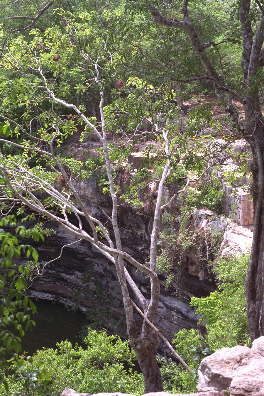
The Sacred Cenote at Chichén Itzá. Photo by B. McKenzie.
In contrast, the Puuc Hills region discussed in our last newsletter sits on an elevated ridge of hills—the Sierrita de Ticul. Because the ground level here rises significantly, the subterranean water table is inaccessible, and Puuc cities relied solely on seasonal rainfall, which was collected and stored in chultuns for the dry season. The Puuc was obsessed with the atmospheric rain god Chac and used this imagery to decorate the palaces and temples of kings. These powerful shaman kings interceded with the gods of thunder and lightening to insure successful arrival of rainy season storms.
THE ATMOSPHERIC RAIN GODS OF THE PUUC
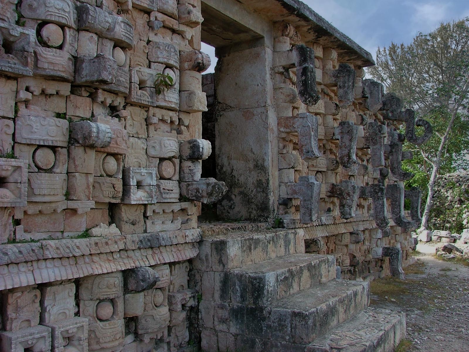
Rain God Masks at Codz Poop, Kabah, Mexico. Photo by B. McKenzie.
Thus geological reality shaped the differing religious imagination and mythological emphasis of each region.
THE CAVES & CENOTES OF CHICHÉN ITZÁ
Guillermo de Anda, director of the Great Maya Aquifer Project, has been exploring the vast and partially submerged cave systems lying beneath the Yucatán Peninsula. He believes Chichén Itzá city planning was shaped by the over 1,025 miles of subterranean caves that his Greater Aquifer Project has discovered so far, and that temples were positioned to reflect this underground natural and sacred geography.
THE PYRAMID OF KUKULKÁN, the Great Feathered Serpent
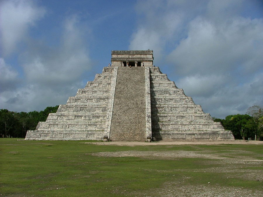
Images of Kukulkan, the great feathered serpent, can be seen, open mouthed, at the bottom of the balustrades bordering the stairs. The columns holding up the roof of the temple at the top of the stairs are also carved to represent feathered serpents. Photo courtesy of Jeff Purcell
For example, El Castillo, the temple dedicated to the great feathered serpent Kukulkan, was placed centrally between four cenotes. Dr. de Anda explains:
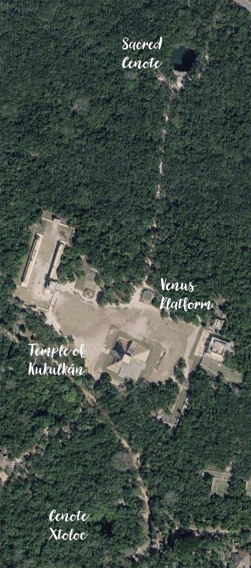
“To the north lies the Sacred Cenote; to the south, Xtolok Cenote; east is Kanjuyum; and west is Holtún. If you trace two lines between the north and south and east and west cenotes, you will find that El Castillo lies at the exact point where these alignments intersect. About five years ago, one of our colleagues, Dr René Chávez Segura, used geophysics to discover what appears to be a cenote under El Castillo. No one has yet been able to get inside this to check the results on the ground, but, if they are correct, it is very important.
“When we think about directions today, we imagine north, south, east, and west. The Maya saw these instead as the colours white, red, black, and yellow. But they also saw a fifth direction: the centre. This sacred direction lay at the centre of space, and the Maya built their religion and lives around it. The centre was extremely significant as a source of both extremely good and extremely bad things.”
Note: Unfortunately, Google Maps does not show Cenotes Kanjuyum and Holtún. However, the serpent heads at the bottom of the north side of Kukulcan facing the Sacred Cenote can be barely made out.
De Anda believes that the Maya were fusing the cenotes and cave systems of the natural landscape with their own urban planning to create a physical expression of the Maya world-view. Xibalba, the Maya Underworld of caves and cenotes underlying the city, was physically made part of urban consciousness in much the same way that subterranean rail lines and metro stops are part of the consciousness of native New Yorkers. Above ground, sacred cave entrances and cenotes were connected by processional sacbé (ceremonial white roads) to the ritual center of the city. De Anda concludes: “We have heard, for a long time, the oral tradition of the elders that El Castillo was built over a cavern or cenote. Our next step is to get into this fifth cenote and prove that it exists”.
The Great Maya Aquifer: exploring a hidden world beneath the Yucatán Peninsula, World Archaeology, Issue 114, July 19, 2022; also see Inside Chichén Itzá-360, National Geographic
A KNOWN CENOTE LIES UNDER THE OSSUARY
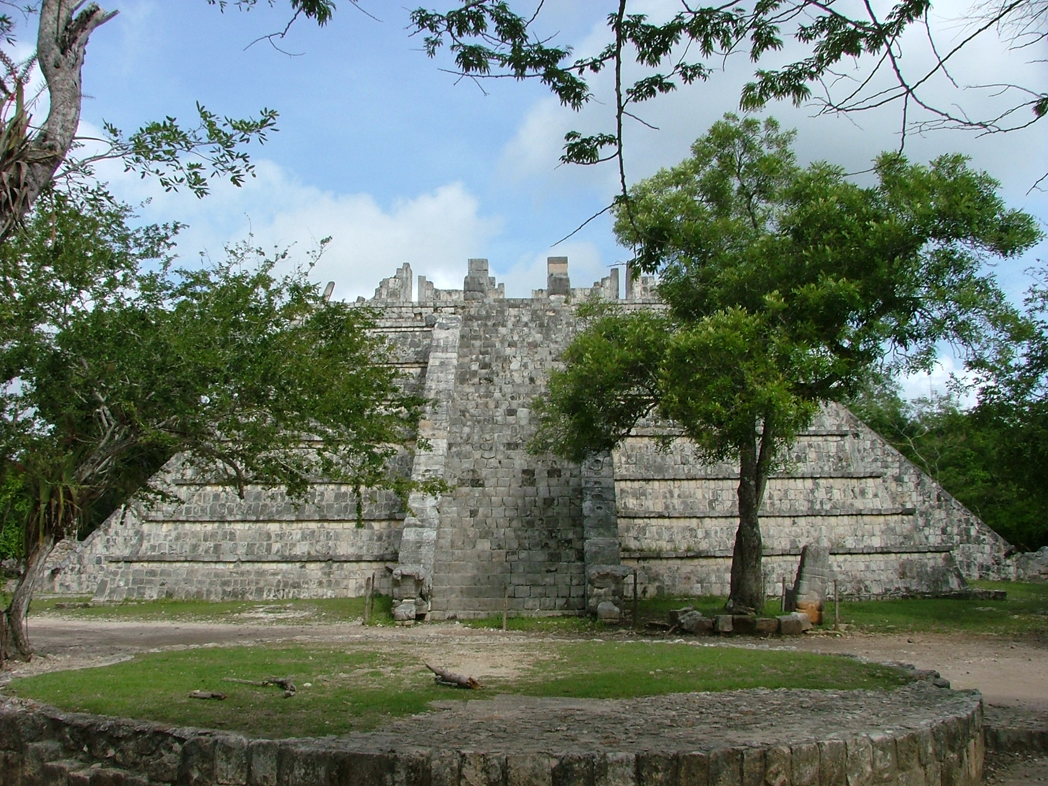
The name "High Priest’s Grave" was given to this structure by Edward Thompson. Photo by B. McKenzie.
While the subterranean cave beneath El Castillo has only been detected with ground-penetrating radar, we know for certain that the earlier Ossuary—which served as the architectural prototype for El Castillo—was built directly over a natural cave and cenote. The stepped pyramid was constructed in nine distinct terraces and reflects the nine levels of the Underworld.
The temple on top of the pyramid has an air intake column and vertical passageway leading to the underground cave and cenote, and is significant to the agricultural calendar because, at the beginning of the rainy season, the sun enters the vertical passageway and illuminates the floor of the cave 10 meters below, fertilizing the earth. Several rich offerings were found on the floor of the cave at this location.
Alfred Maudslay observed nearly a century and a half ago that the ground plan around the Ossuary bears an unmistakable resemblance to that of the later Castillo. Both temples are oriented toward the east and feature four radial stairways flanked by serpent balustrades leading to an upper sanctuary. Furthermore, each temple rests within a plaza large enough to accommodate large crowds, was fed by radiating sacbé, and had a Venus Platform for the performance of public dance and ritual.
THE OSSUARY & ITS SUBTERRANEAN SHAFT
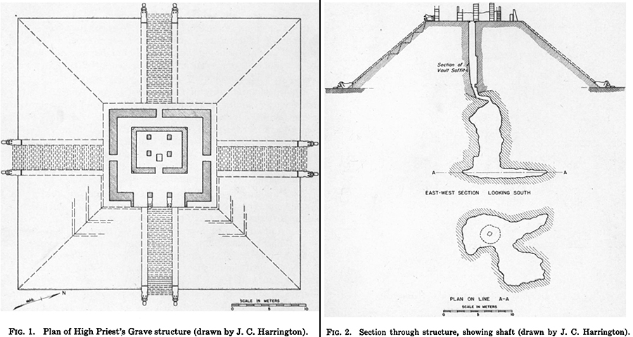
NOTE: the entrance to the shaft leading to the underground cave and cenote is the small square in front of the entrance to the inner temple in the diagram on the left. From Thompson, Edward H., and J. Eric Thompson. “THE HIGH PRIEST’S GRAVE: CHICHEN ITZA, YUCATAN, MEXICO.”.
The sanctuary at the summit holds the opening to a vertically engineered masonry shaft which pierces the pyramid and drops ten meters directly into the natural cavern beneath. At the solar zenith in late May which marks the onset of the rainy season, the midday sun aligns with this vertical chimney and illuminates the cave below. Edward Thompson was the first modern archaeologist to lower himself into this pit:
The next day was spent in arranging for the descent, and the following day I was let down by means of a rope and blocks into the pit. My previous experience in subterranean chambers had familiarized me with this class of work. The clear flame of my lantern relieved me of any fear of mephitic air, and with my keen bowie knife between my teeth ready for instant use, and lighted lantern in one hand, I examined the walls of the pit as I went down. The pit seemed to be in part the work of nature, but greatly changed and enlarged by the work of the ancient people.
I touched bottom upon a heap of earth near the center of the chamber and directly under the orifice where the candlelights of my anxious boys gleamed like stars above me. I sent up a reassuring call that all was well and commenced my investigations. My brush had hardly raised dust when I found that my expectations were to be realized. A bead of jade over five inches in circumference, beautifully formed and so polished that it gleamed under the light of my lantern, was right at my feet, and close beside was a beautiful jade amulet.
Thompson, Edward H., and J. Eric Thompson. Publications of the Field Museum of Natural History. 1938, p. 29.
While mapping this shaft a few years later, J.C. Harrington discovered the vault profile of an earlier temple embedded within the pyramid fill (visible in the cross-section above), proving the structure had expanded over multiple construction phases. Harrington later wryly recalled his own descent:
Many years ago the reviewer allowed himself to be lowered by two monolingual Mayans to the bottom of the subterranean cavern under the High Priest’s Grave at Chichen Itza, having prepared for the exploit by memorizing the Maya words for up and down.
Harrington, J. C. American Journal of Archaeology, vol. 58, no. 2, 1954, pp. 183–84. JSTOR, https://doi.org/10.2307/500139. Accessed 7 Sept. 2025.
THE COLLAPSED OSSUARY & BALUSTRADES IN 1889
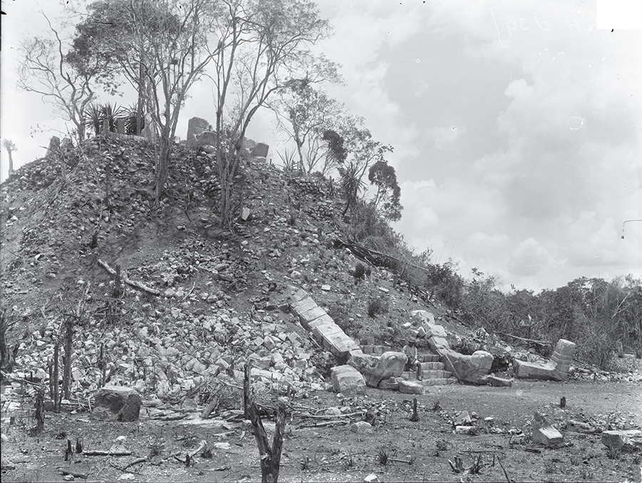
From the Maudslay Collection, British Museum. Used with permission under the CC BY-NC-SA 4.0 non-commercial license. ©The Trustees of the British Museum.
The fully conceived Feathered Serpent architectural elements of the Ossuary are documented by Alfred Maudslay’s 1889 photographs. At the base of the collapsed eastern stairway, the massive stone heads of Kukulkan lie in their original positions, while to the right of the stairs sits part of a fallen L-shaped serpent body column which once held up the entrance to the sanctuary at the top.
SERPENT COLUMNS CROWN THE OSSUARY SUMMIT
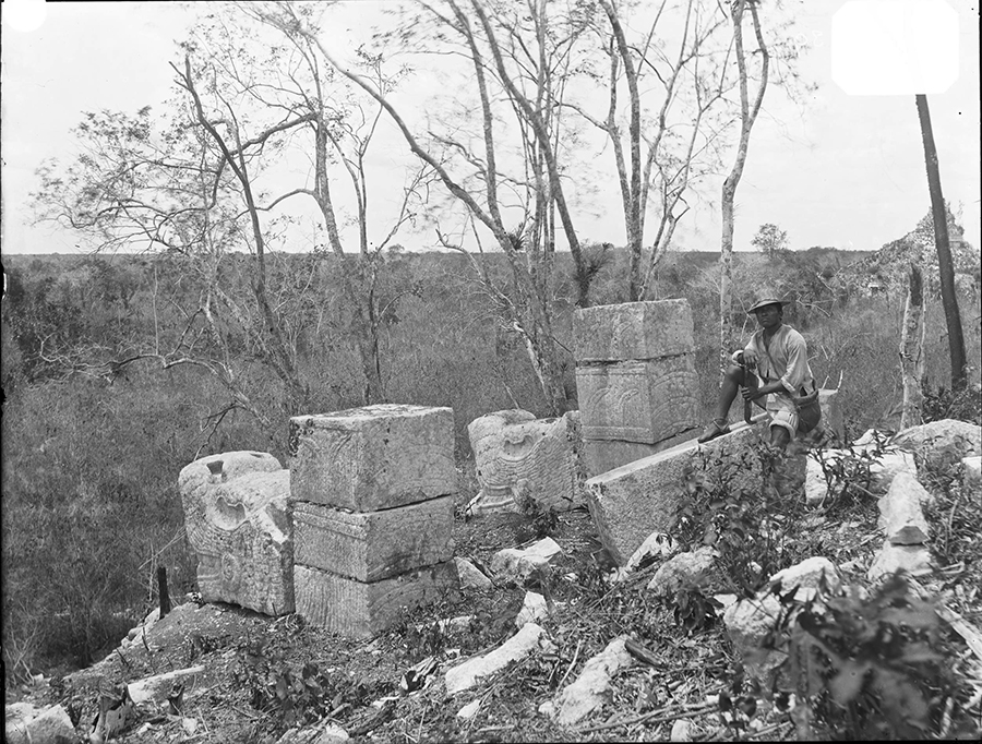
The feathered serpent heads and columns guarding the entrance of the temple as they appeared in 1889. This entrance led to an inner ambulatory which surrounded the temple proper. From the Maudslay Collection, British Museum. Used with permission under the CC BY-NC-SA 4.0 non-commercial license. ©The Trustees of the British Museum.
At the summit of the pyramid—steps away from where the vertical shaft plunged down into the cave—Maudslay photographed the remains of the upper temple portico. The rectangular-cut columns forming the body of Kukulkan stood here, their surfaces carved with quetzal plumes and reptilian belly scales. Before this imagery was later replicated on the colossal terraces of El Castillo and the Temple of the Warriors, the Feathered Serpent was standing sentinel here, marking the threshold of the underworld.
FEATHERED SERPENTS SPREAD ACROSS “NEW CHICHÉN”
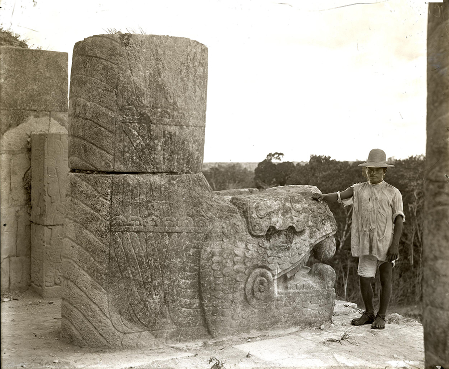
From the Maudslay Collection, British Museum. Used with permission under the CC BY-NC-SA 4.0 non-commercial license. ©The Trustees of the British Museum.
Expanding beyond the precinct of the Ossuary into the great civic spaces of “New Chichén,” this serpent program exploded across the urban landscape. In Alfred Maudslay’s 1889 photograph of the Upper Temple of the Jaguars, a local Maya stands next to a serpent column head for scale. The anatomical carving is crisp and formidable: belly scales under the raised body, quetzal feathers at the neck, eagle feathers on the face, and an open mouth with large fangs.
David Stuart, in The Four Heavens: A New History of the Ancient Maya, notes the nonlocal flavor of this imagery:
Many of the buildings are also covered in the powerful images of feathered serpents. We see this most in the “Castillo” of Chichen Itza, still known in Landa’s time as the Temple of K’uk’ulkan (“Feathered Snake”). The Balustrades of its northern stairway, as well as the columns of its upper temple, are carved as descending feathered serpents. Taken together, these new architectural elements evoke a decidedly non-Maya, or nonlocal, flavor. But it wasn’t a complete overlay of new over old, for in many places we we still see the mosaic masks of Puuc style integrated with this new imagery or even familiar elements of Maya iconography. There is an imposition of a new ideology and art over what was before, but it is not a wholesale replacement of the Maya by foreigners. It is this mix that makes Chichen Itza so compelling—and so complex for us archaeologists.
David Stuart, The Four Heavens: A New History of the Ancient Maya, Princeton University Press, 2026, p. 333-4
REATTACHED RATTLESNAKE TAILS
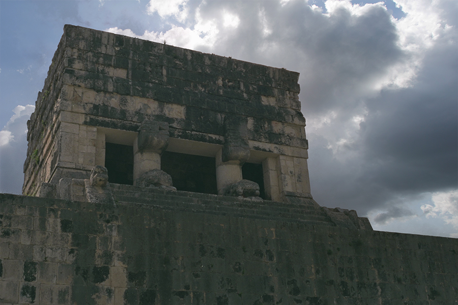
Photo by B. McKenzie.
When the Upper Temple of the Jaguars was consolidated, the vertical column shafts and rattlesnake tails were re-erected to support the rebuilt façade lintel, showing how these serpentine supports originally functioned.
SERPENT HEADS BURIED IN “MOUND 14”
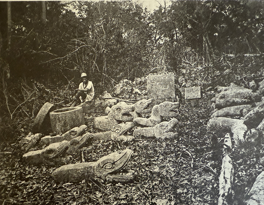
From the Maudslay Collection, British Museum. Used with permission under the CC BY-NC-SA 4.0 non-commercial license. ©The Trustees of the British Museum.
When Alfred Maudslay arrived at Chichén Itzá in 1889, he was dismayed to find the Venus Platform (which he called Mound 14) gutted by the eccentric antiquarian Augustus Le Plongeon. Le Plongeon had dug out the core of the mound and dumped its contents down the slope. Yet Maudslay’s photograph of the aftermath hints at the volume of sculpture required to outfit the city’s public platforms.
NOTE: Le Plongeon had arrived in Chichén Itzá in 1873, prior to Maudslay’s tenure, where he discovered and named a large Chacmool statue. Ian Graham, Maudslay’s biographer, describes La Plongeon as “the very archetype of the imaginative and deluded antiquary. With his bald head, penetrating gaze, long straggly beard, and confident knowledge of recondite histories, Augustus Le Plongeon must have made a deep impression in Yucatán. Some, however, were less deeply impressed, including the Mexican government, which confiscted his Chacmool, to his acute indigation.”
MASSIVE FEATHERED SERPENT COLUMNS
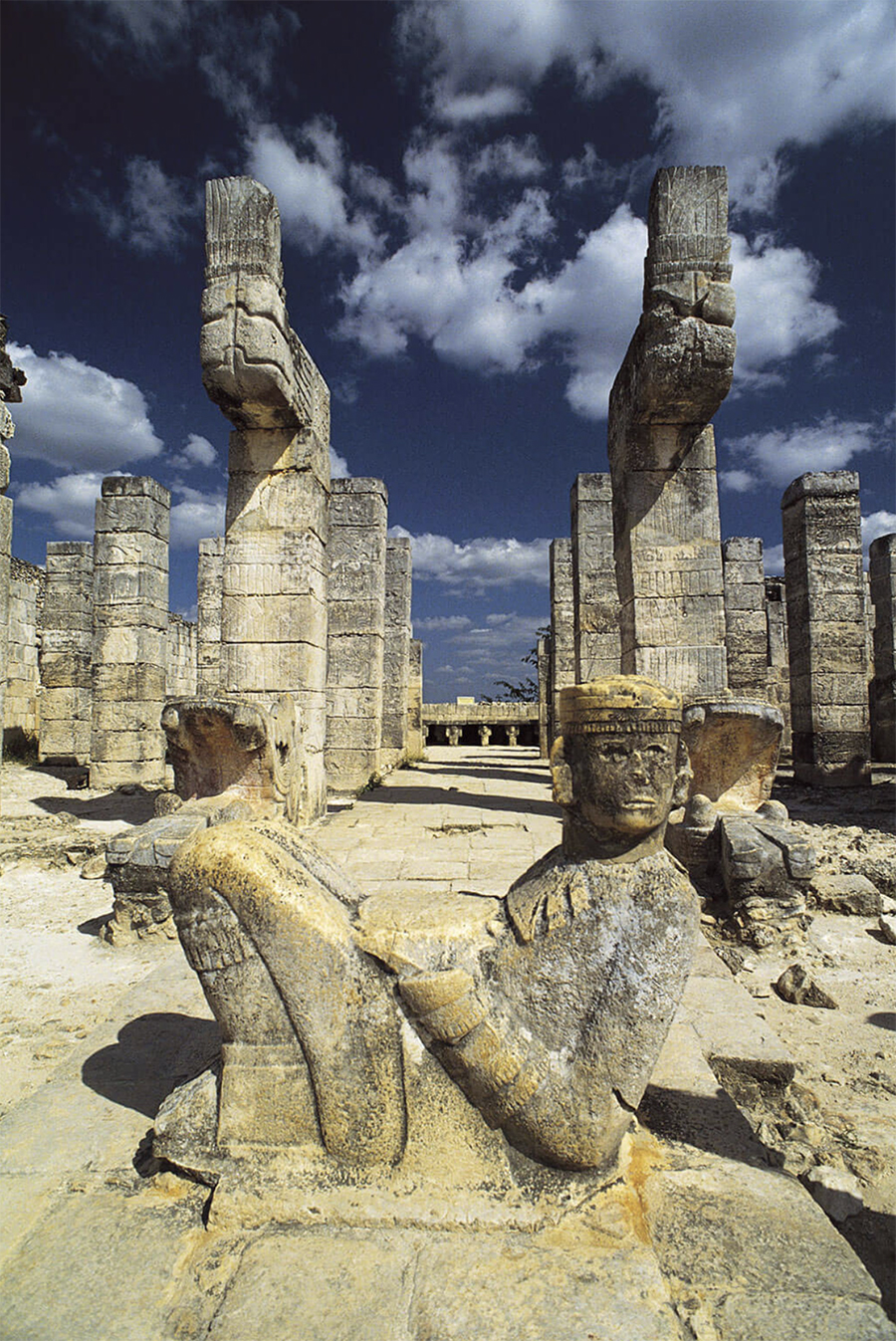
This famous photo is property of Instituto Nacional de Antropología e Historia, Gobierno de México, and is being used here for non-commercial purposes.
At the Temple of the Warriors, architectural stagecraft reached its peak. Two massive serpent columns rise vertically at the entrance, their tails once supporting a wooden lintel spanning the broad portico. In the foreground, a reclining Chac Mool holds an offering disk over its abdomen. David Stuart observes:
During the tenth and eleventh centuries, Chichen Itza was the dominant political center of the region, but it was also a radical experiment, built to express a newly forged ideology of warfare, sacrifice, and sacred water. It represented an idea that later Mesoamerican histories cite using the concept of a Tollan, the Nahuatl name meaning “Place of the Bulrushes,” referring to an idealized place of origin and political authority. ... As several scholars have proposed, Chichen Itza was also probably conceived as a “Tollan” in its day, serving much the same role as Teotihuacan did in the more ancient past. This is when the Early Postclassic era truly began, and the Classic system of Maya courts was no more.
David Stuart, The Four Heavens: A New History of the Ancient Maya, Princeton University Press, 2026, p. 339
FROM INTERNAL SHAFT TO SHADOW THEATER
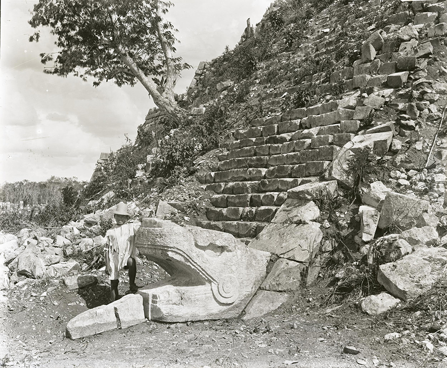
Feathered Serpent head from base of the Temple of Kukulkan. From the Maudslay Collection, British Museum. Used with permission under the CC BY-NC-SA 4.0 non-commercial license. ©The Trustees of the British Museum.
Even though the Ossuary had earlier established the “New Chichén” temple prototype with its radial stairs, serpent balustrades, and subterranean chamber, there was one decisive difference: the Ossuary produced no equinox shadow.
The Ossuary was calibrated for an internal solar event, channeling the rays of the midday zenith sun down its chimney shaft to illuminate the cave floor below. When designing El Castillo, the architects shifted this celestial drama from an interior shaft onto the public plaza. They oriented the massive pyramid so that the setting sun of the vernal and autumnal equinoxes animated the northern balustrade, turning stairway into a moving serpent.
NOTE: Ritualizing the fall of light and shadow as it occurs on solar equinoxes and solstices and constructing temple complexes to celebrate the position of sunrise on these dates was a feature of Maya architecture dating back at least to PreClassic times (1000 BC).
DESCENT OF KUKULKAN INTO THE CENOTE
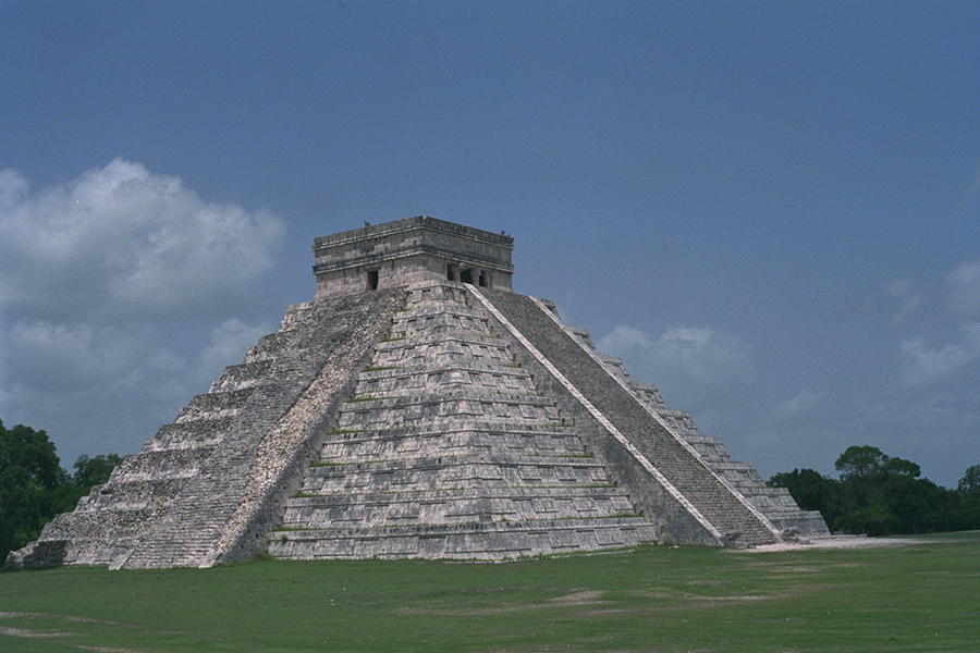
Feathered Serpent heads decorating the balustrades can be seen at the bottom of the stairway on the right. Photo by B. McKenzie
During the spring and autumn equinoxes, the stepped terraces of the pyramid cast seven undulating triangles of shadow along the western alfarda of the northern staircase, creating the visual impression of a colossal serpent slithering down from the summit temple toward the earth. Local tradition holds that the plumed serpent continues along the northern processional sacbé, where it disappears into the dark waters of the Sacred Cenote.
Last spring, an estimated 8400 people jammed into the plaza surrounding El Castillo to witness this event. Yucatan Magazine describes it thus:
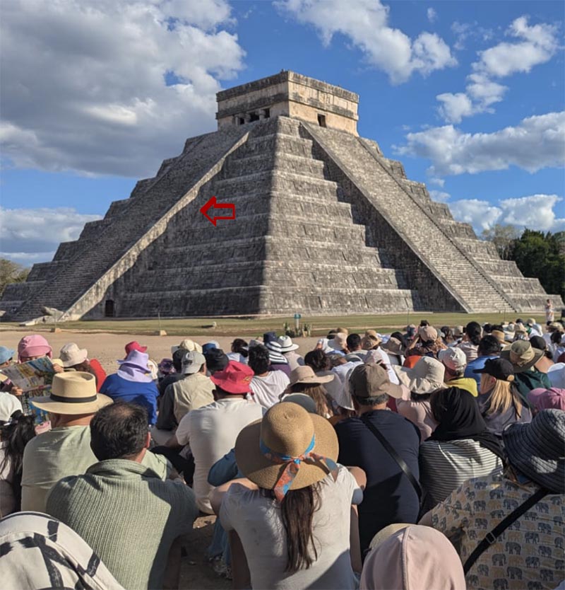
“On the western side of the alfarda of the north staircase of the building called El Castillo, the visual effect produced by the sections of the base formed seven arcs of shadow that, for some 30 minutes, give the appearance of the undulating body of a serpent descending and beginning its journey toward the Cenote Sagrado,” the INAH Yucatán delegation noted.
Yucatán Magazine, March 22, 2026, has a video of Kukulkan descending the temple steps.
THE SACRED CENOTE IN 1889
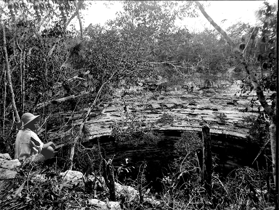
From the Maudslay Collection, British Museum. Used with permission under the CC BY-NC-SA 4.0 non-commercial license. ©The Trustees of the British Museum.
The Sacred Cenote was a ritual center and place of pilgrimage throughout Chichén Itzá’s long history. Even after the city’s abandonment sometime before 1200 AD, it remained a place of pilgrimage and a place to make valuable offerings to the gods in time of drought.
When the Franciscans arrived in the mid-1500s, the Sacred Cenote was still an active pilgrimage site. Friar Diego de Landa, in his 1574 report to the King of Spain (Relación de las Cosas de Yucatán), wrote:
Into this well they were and still are accustomed to throw men alive as a sacrifice to the gods in times of drought; they held that they did not die, even though they were not seen again. They also threw in many other offerings of precious stones and things they valued greatly; so if there were gold in this country, this well would have received most of it, so devout were the Indians in this.
The Sacred Cenote of Chichén Itzá. Artes de México, no. 152, 1972, pp. 76–80. JSTOR, http://www.jstor.org/stable/24317068. Accessed 9 Feb. 2025.
CARVING ON THE SACRIFICIAL PLATFORM
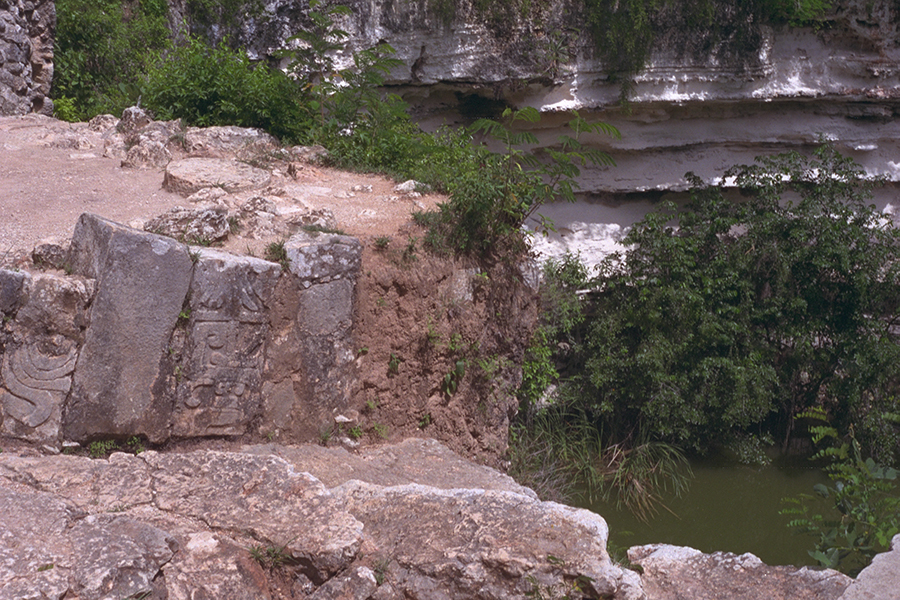
Photo by B. McKenzie
This portion of the building on the cenote’s lip is thought to be the platform from which offerings were thrown into the cenote. Clemency Coggins, in her introduction to the Peabody Museum’s 1984 exhibition catalog of objects retrieved from the Sacred Cenote, writes:
Although the bishop had no way of knowing if the ancient Maya had ever had any gold (and really they did not), he had been right about gold in the Sacred Cenote of Chichén Itzá. The gold was hammered or cast in the lower Central American regions of its origin. Similarly, copper was probably hammered and cast far from Chichén Itzá, in Central Mexico, Oaxaca, the Guatemalan highlands, or Honduras. These exotic riches testify to widespread contact with Chichén Itzá, and to the singular fame of the Sacred Cenote.
Clemency Chase Coggins, editor. Cenote of Sacrifice: Maya Treasures from the Sacred Well at Chichén Itzá. University of Texas Press. Austin. 1984, p. 23, 27
DESCENT INTO THE SACRED CENOTE
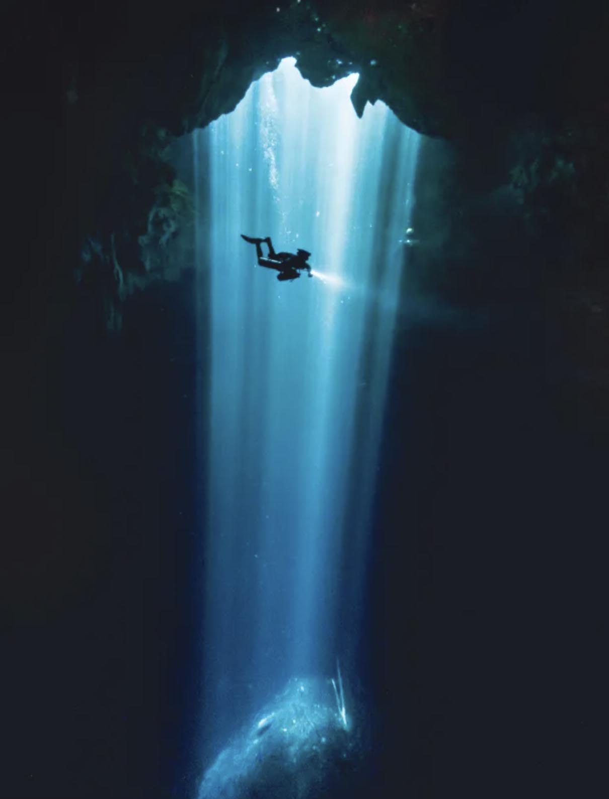
The Great Maya Aquifer: exploring a hidden world beneath the Yucatán Peninsula. Diver exploring the Great Maya Aquifer. Photo by Ricardo Castillo.
David Stuart notes: “Chichen Itza’s unique and imposing cenote, a wide hole into the watery “otherworld,” had always been a profoundly sacred place. Now, its role was renewed and repurposed in the wake of the old Classic order, as it came to be appropriated by a group of powerful outsiders as the epicenter in a new ideological, political, and commercial system. I suspect the great cenote was the main attraction all along, a powerful draw for elites even as the political and cultural world was rapidly changing.”
David Stuart, The Four Heavens: A New History of the Ancient Maya, Princeton University Press, 2026, p. 338
DIVERS AND CAVERS VISIT XIBALBA
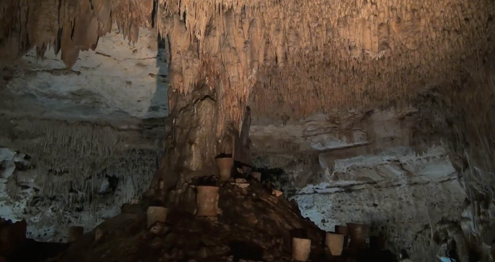
From YouTube Video: "Dr. George Stuart explores Balankanche Cave, Yucatan."
Balankanche Cave, near Chichén Itzá, is spectacular and vast. This cave had been known for many years, but in 1958 George Stuart was informed that a formerly walled off section had been discovered. He was tasked with the responsibility of mapping the cave, and this video documents the project and has spectacular footage of the cave and its explorers. A marvelous invocation of the adventures and dangers of cave discovery and exploration.
THE SEVEN GODS OF XIBALBA
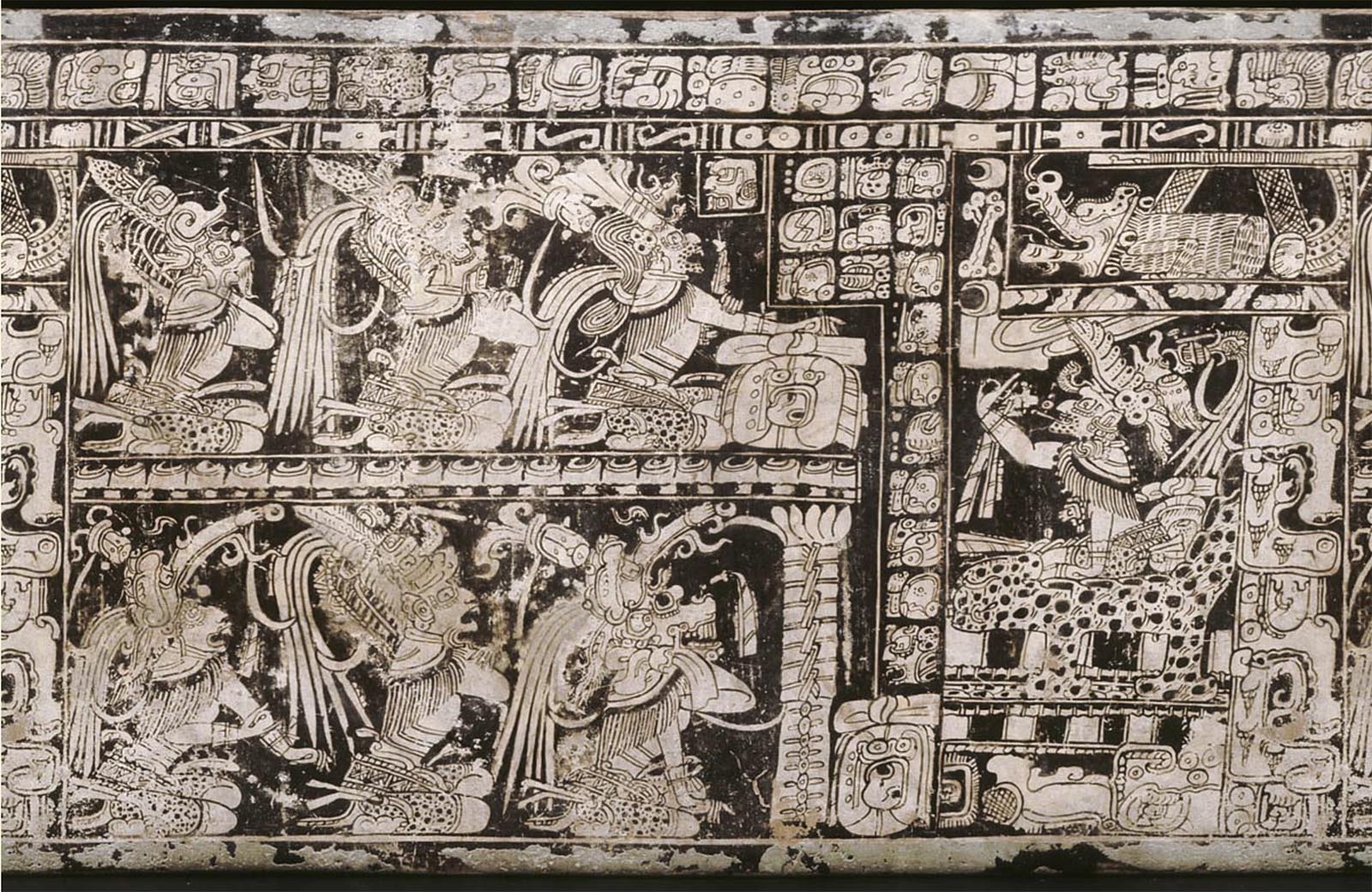
Justin Kerr Rollout photo of vase K2796
To understand what the pilgrims and priests imagined when looking down into the green waters of the Sacred Cenote or crawling through the narrow limestone passages of Balamkú or Balankanché caves, one must turn to Classic Maya narrative ceramics.
On vessels such as the Vase of the Seven Gods (K2796), the Maya rendered this subterranean world in stark black and white. Seated upon a jaguar throne within his underworld palace is God L, the ancient, cigar-smoking sovereign of the subterranean realm, wearing his diagnostic screech-owl headdress featuring Muwaan, the bringer of bad omens. Kneeling before him in two tiers are six underworld lords—including the Jaguar War God and skeletal deities marked with putrefaction signs.
To the maya, the natural limestone caves beneath Chichén Itzá were the physical, administrative courts of God L and his council. Offerings cast into the Sacred Cenote were tribute payments delivered directly into their watery halls.
OFFERINGS IN CHICHÉN ITZÁ’S CAVES
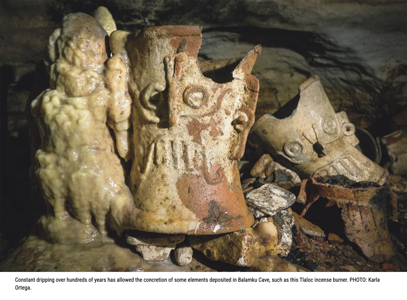
The Great Maya Aquifer: exploring a hidden world beneath the Yucatán Peninsula. (Photograph by Karla Ortega: a close-up from Balamkú Cave showing ancient ceramic incensarios molded with the diagnostic goggled eyes, ringed nose-piece, and fangs of the Central Mexican rain deity Tlaloc; centuries of mineral-rich water dripping from the cave ceiling have entombed the vessels in thick, glistening calcite flowstone/concretion).
Beyond the great sinkholes open to the sky, ritual activity was deeply embedded in the labyrinthine caves beneath the city. At Balankanché, four kilometers to the east, and more recently at Balamkú (rediscovered by Guillermo de Anda's team), archaeologists encountered sealed sanctuaries untouched for centuries.
Guillermo de Anda’s short video of his team’s descent into the Balamkú cave conveys something of the extraordinary difficulties experienced by de Anda’s team when visiting the sacred subterranean spaces of Balamkú Cave.
Deep within these damp, claustrophobic chambers, priests deposited dozens of incensarios modeled with the visage of the Central Mexican rain deity Tlaloc, along with miniature metates, spindle whorls, and jade beads. Deposited in chambers that required hundreds of yards of crawling through total darkness, these offerings were direct appeals made directly in the chambers of the underworld, Xibalba, the place of fright.
Note: Balamkú Cave should not be confused with Balamkú ruins in Campeche, which is famous for an exceptionally well-preserved Early Classic facade discovered within a buried temple.
CHICHÉN ITZÁ’S SUBTERRANEAN LANDSCAPE
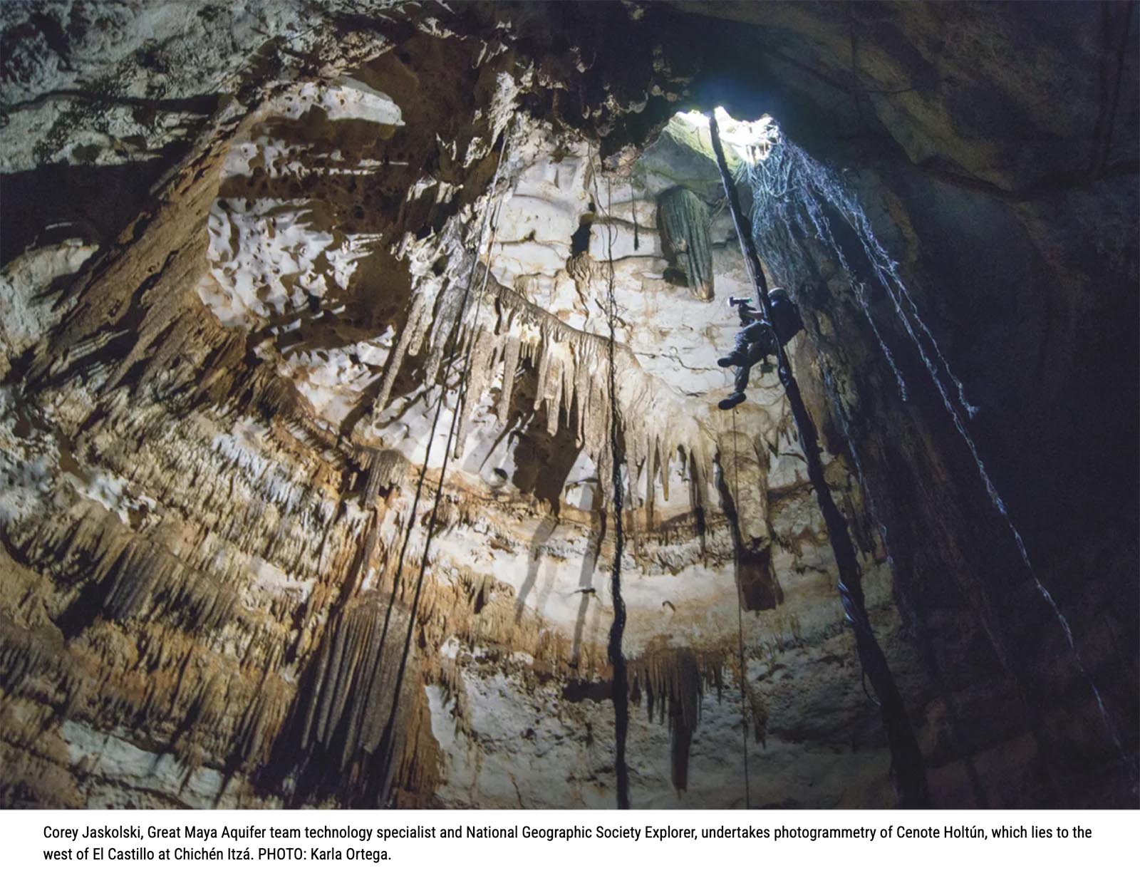
The Great Maya Aquifer: exploring a hidden world beneath the Yucatán Peninsula. (Photograph by Karla Ortega showing Corey Jaskolski, Great Maya Aquifer technology specialist and National Geographic Explorer, suspended mid-air on vertical climbing ropes beneath the ceiling portal of Cenote Holtún, conducting photogrammetry amidst hanging tree roots and massive cascades of stalactites).
While writing of the cave systems of the Maya lowlands to the south, archaeologist Jaime Awe captures the psychological weight these subterranean spaces held across the Maya world:
Below our feet, below the jungle floor, lies a hidden realm of caverns and caves, spectacular columned galleries stretching beyond the limits of even the most powerful of headlamps, rushing rivers in steep-walled canyons, and crystal-clear lakes, eerily still in the murky and musty darkness. It is to these locations that the ancient Maya, both elite and non-elite, went to commune with deities and ancestors, to conduct funerary rituals, rites of socio-political transition, to mark their borders and the passage of time, and perhaps even to divine their futures.
Beyond the Twilight Zone: Cave Exploration in the Macal River Valley, Belize Jaime J. Awe, Christophe Helmke, and Shawn G. Morton, in "The Realm Below: Speleoarchaeological Investigations in the Macal River Valley, Belize"
More information about Chichén Itzá is available in the Chichén Itzá section of the MayaRuins website.
Comments? Questions? Let us know at newsletter@mayaruins.com
Our next issue, The Fall of Chichén & The Rise of Mayapán, focuses on a daring political coup de etat at the Sacred Cenote which led to the sacking of Chichén Itzá and established Mayapán as the last great Maya city prior to the coming of the Spanish.
NOTE: Visit our ARCHIVE for past newsletters.