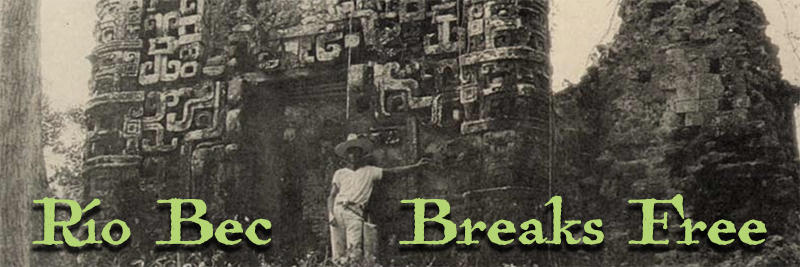
Photo from Ruppert & Dennison‘s Archaeological Reconnaissance in Campeche, Quintana Roo, & Peten”s, Carnegie Institution of Washington D.C., 1943, p. 40
If you missed earlier newsletters on El Mirador or Calakmul, they are available online in our Insights Archive.
The Thumb of the Kaloomte’ (Overlord)
When Yich’aak K’ahk’ of Calakmul was routed by the armies of Tikal in 695 AD, economic shockwaves rippled far beyond the Petén jungle. For the rich agricultural lands of the Río Bec region to the north, Calakmul's defeat meant one thing: the massive, generational outflow of tribute stopped. The Río Bec was finally free to keep its own wealth, which it would use to fund a spectacular regional architectural renaissance of its own.
What is patan (tribute)?
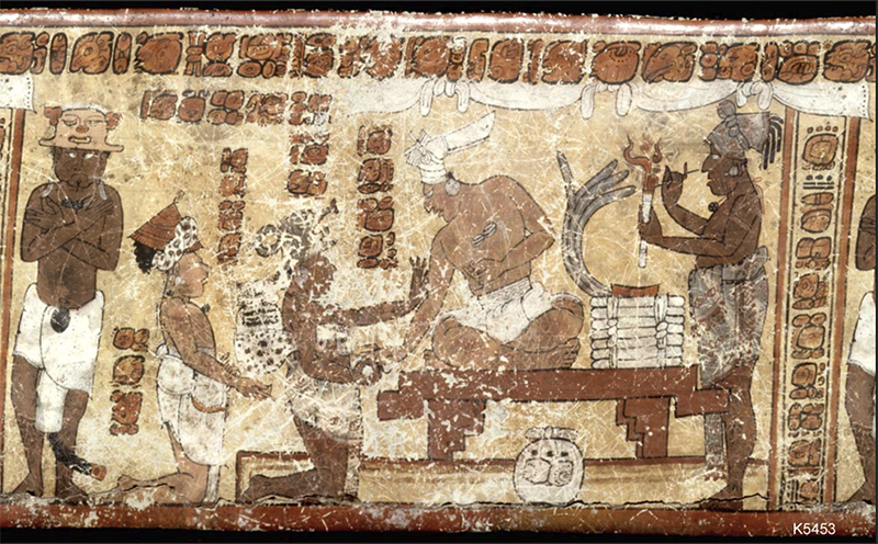
Rollout photograph by Justin Kerr, vessel K5453
When Calakmul lost to Tikal, it not only lost many of its tribute-paying vassals, but also suffered the humiliation of itself having to pay tribute, as shown in the painted vase above where a Tikal lord received tribute from the defeated Calakmul court:
An ebeet messenger in the service of Yuknoom Yich’aak K’ahk’ [Fiery Jaguar Paw] of Calakmul delivers a gift or bundle of tribute to a Tikal lord on the vessel K5453. Most examples are seen on painted vessels, where we find visitors with titles of ebeet, “messenger” or muut, literally “bird ” but meaning “messenger” or “emissary”.
Simon Martin, “Ancient Maya Politics: A Political Anthropology of the Classic Period 150-900 CE”, Cambridge University Press, 2022, p. 336-7
The ebeet from Calakmul is kneeling next to the throne on the left. His tribute, consisting of green quetzal feathers atop bolts of woven cotton cloth, sits on the throne while a sack labeled as 24,000 cacao beans—cacao as well as cotton mantles functioned as a kind of cash for the Maya—sits in front. Note the courtier on the right lighting thin cigars as an offer of hospitality to the emissaries.
The Tribute Transport Problem
In the Classic Maya world, exporting bulk staple crops (like maize or beans) across long distances was highly inefficient. Because human porters consume a portion of the load for every day they travel, transporting staples beyond local distances resulted in diminishing returns. It was much more efficient for staples to stay in the Río Bec region, and for tribute to be paid with high-value goods like:
-
Cotton Textiles: Thousands of woven cotton mantles were produced by women of the Río Bec elite and commoner classes. J.P. Baron examines early monetization of cacao beans [not a product of the Río Bec] and cotton textiles among the Classic Maya: these products, originally valued as high-status objects, took on monetary functions as the network of marketplaces increased among rival Maya kingdoms. As a result of this monetization, cacao and textiles could be used to finance both activities of the ruling classes as well as provide for ordinary household needs. Thus, political overlords extracted massive quantities of textiles from subordinate regions to fund their empires, and the women of the Río Bec, although not exactly printing money, were literally weaving it.
Baron, J. P., Making money in Mesoamerica: Currency production and procurement in the Classic Maya financial system. Economic Anthropology, 3(2), 2016, p. 210-223]
- Forest products—Honey, wax and copal incense: The jungle of the broader Campeche/Yucatán peninsula is historically famous for its stingless bee honey and wax, heavily used in rituals and trade, and for the copal incense required for rituals.
- Crafted Chert and Obsidian: Polyhedral obsidian cores and striking debitage found at Becán indicates that raw, prepared cores from the Guatemalan highlands and Central Mexico were imported and local Becán specialists manufactured the finished blades and ritual objects on-site. [Rovner, I., Anomalous patterns of obsidian importation in the central Maya lowlands, 1981]
- In addition, Becán and the surrounding Río Bec elites would have been expected to provide military contingents to march under the Kaanul banner in their perpetual wars.
By breaking free, the region now controlled its own wealth, i.e., its currency equivalents, and no longer had to send its young men into the forever Petén wars. This new wealth fueled the architectural flowering about to take place and financed the construction of Río Bec’s theatrical new cities.
The Economic Foundations of the Río Bec Region
The Río Bec region was uniquely positioned to thrive after the decline of Calakmul. Unlike Calakmul (or its arch-rival Tikal), where massive reservoirs were required to store water during the dry season and divine kings provided the top-down social control to manage elaborate hydraulic engineering projects, farmers in the Río Bec relied on natural rainfall and small-scale terracing of the landscape to prevent soil erosion and maintain soil fertility. Because terracing could be managed by extended families, wealth and power were inherently decentralized. The landscape was dotted with wealthy, self-sustaining agricultural estates that did not need the organizational control of a divine king. Thus the distribution of wealth, both in terms of land ownership as well as the cottage industries producing cash equivalent products like textiles or obsidian blade finishing, could be highly decentralized across the region.
Turner, B. L. II, Once Beneath the Forest: Prehistoric Terracing in the Río Bec Region of the Maya Lowlands, Westview Press, Dellplain Latin American Studies, No. 13. Published in cooperation with the Department of Geography, Syracuse University. Westview Press, Boulder Colorado, 1983
The Río Bec Sites
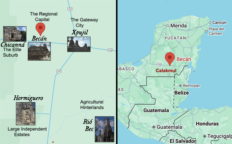
Becán and Xpujil, the major cities of the Río Bec, and Becán’s elite suburb, Chicanná, all lie along the cross-Yucatan overland trade route now traced by highway 186, while in the south, large and small independent estates were scattered over the agricultural hinterlands.
Becán: the ancient Río Bec capital
Becán has roots and importance extending deep into the antiquity of the Pre-Classic. Later, after this area became a vassal of the Snake Kingdom in the Late Classic, Becán became a regional bureaucratic and tax collection center. If Calakmul or Dzibanché needed a levy of warriors from the Río Bec region or a massive shipment of woven cotton mantles, they demanded it from the lords of Becán, who then extracted payment from the elite landowners of the area.
Portrait of an early Becán Bureaucrat

Photo courtesy of Jeff Purcell
This Early Classic stucco was discovered in the small elite residential courtyard at Becán. The iconography is standard Early Classic Maya, but I like to think it more likely represents a nobleman whose family lived in the courtyard, dressed up in the costume of the sun god Kinich Ahau.
The elite class governing Becán during its time as a vassal state were bureaucrats and not kings in the style of the divine overlords of Calakmul or Tikal. They were wealthy, highly educated administrators, diplomats, and emissaries (ebeet and lakam) who, residing in the borderlands, facilitated the geopolitics of larger empires. Becán raised no stelae commemorating the investiture of its kings or celebrating their conquests or ritual acts. Even though they were the paramount rulers of the region, the lords of Becán were primarily administering the tribute due to foreign powers or negotiating with—or being subjugated by—empires like Teotihuacan, Tikal, or most significantly, Calakmul.
Becan Structure IV

LEVEL 1: Grand staircase to Lvl 2; low rooms at the sides of the stair may have controlled access to the public areas above.
LEVEL 2: Many rooms opening onto a grand terrace; rooms have benches, platforms, cordholders and appear to have had public or administrative functions. Terrace is level with the S.E. plaza floor.
LEVEL 3: Accessible only from courtyard on south side of building; Evidence of drains & primitive toilet complete with graffiti. This level appears to have been part of the upper level residential complex.
LEVEL 4: Open residential courtyard; Rooms on three sides; Entrance from grand staircase on S.E. Plaza but no access from the north side of the building. Please enjoy additional photos and detailed diagrams of this charming courtyard!
As the power of Calakmul faded and extraction of tribute from the Río Bec region subsided, an explosion of architectural and artistic creativity was unleashed throughout the region—in the capital at Becán, in intermediate-sized cities, as well as in the estates of elite landowners spread over the countryside.
Structure IV at Becán is a good example of the architectural innovations of the time. It employed new core-and-veneer technologies (rubble bound with lime mortar, faced with non-structural dressed stone), a dramatic departure from the heavy, load-bearing block masonry of Calakmul and Tikal.
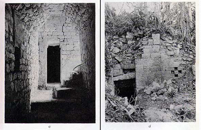
Because this method of construction was much lighter, the construction material did not crush its internal voids. Buildings could be honeycombed with internal staircases and internal rooms, passages and hidden storage areas.
Ruppert, Karl & John H. Denison, Jr. Archaeological Reconnaissance in Campeche, Quintana Roo, & Peten. Publication 543. Washington D.C. Carnegie Institution of Washington. 1943, Plate 21c & Plate 21d
Paul Gendrop, the architectural historian, writes:
We should also note the quantity of passageways, tunnels, and chambers that often perforate the solid mass of some foundations. In Structure IV at Becán, the intricate though regular chain of chambers and inner passages, as well as those strange passageways that begin in the back of the south façade and go mysteriously down to a chamber that must have had a disguised opening among the barroque decorations of the western façade. A true architecture of moles, one might say, on seeing the results of a design so deliberately convoluted (which implies a no less costly labor of intricate containing walls and fill).
Paul Gendrop. Rio Bec, Chenes, and Puuc Styles in Maya Architecture. Translated from the Spanish by Robert D. Wood, S.M. Labyrinthos, Lancaster, California, p. 63
In the old jungle kingdoms of the Petén, pyramid-temples and low residential building grouped around courtyards are clearly distinguishable. In contrast, Structure IV mixed administrative functions (which occupied the first two floors) with a residential courtyard and apartments on the top floor, serviced by third-floor storage areas, hidden staircases, and ancient toilets complete with graffiti.
Structure VIII

Of course, the builders at Becán still included massive pyramids in their repertoire of available designs, but with an interesting twist. In this photo, a Río Bec range-type palace, book-ended with pseudo-pyramids, is placed on top of a genuine pyramid, resulting in a highly unusual mixing of styles.
The apartments of the Annex of Str. IV

Photo by Jeff Purcell [February 20, 1997]
A birds-eye view of the rooms of the Str. IV annex, which presumably served public or administrative functions. One approached a Maya noble through a series of antechambers, each raised progressively higher by a series of elevated platforms. As seen in the photo, the platforms often had niches in their base, presumably providing for storage.
Str X & ballcourt: Religious & Ritual significance

Throughout its history, Becán was a regional commercial, cultural, and religious center. Seen here is its ballcourt, a feature seen in all Maya city-states, where deep myths of a primordial ballgame between the forces of death and fertility were reenacted. Becán was also an important regional commercial center able to exert control over portions of the important east/west overland trade route which traverses the Yucatan Peninsula.
The Mexican Instituto Nacional de Antropología e Historia de México's (INAH) website, called Lugares INAH, has a spectacular drone fly-over video of Becán, showing the layout of the city with its many temples and public plazas. More information can also be found on the MayaRuins website.
Río Bec and the rural elite landowners
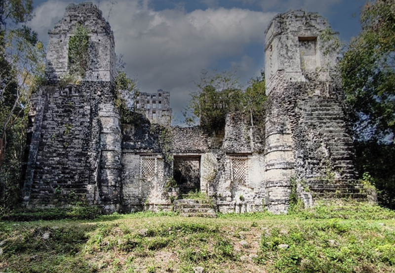
Turning from the urban capital of Becán to the Río Bec region to the south, we see how the new core-and-veneer architectural techniques were adopted, on a smaller scale, in the agricultural hinterlands. Extensive excavation and mapping of Río Bec by archaeologists revealed the highly unusual nature of the region: it has almost no central civic plazas or massive public arenas. Instead, it is a decentralized patchwork of incredibly ornate, sprawling residential palaces spread out across prime agricultural land made productive by centuries of terracing and soil conservation efforts.
The current consensus is that these rural ‘haciendas’ were built by highly successful, and probably non-royal, land-holding local elites. They had grown wealthy managing the agricultural lands that provided the streams of tribute that had fed the Petén power centers in the past. These land-holding elites adopted the new architectural vocabulary of the capital—adding pseudo Petén-style pyramids to their houses and carving serpent masks—to mimic the innovations of the urban elite at Becán and Xpujil.
The Río Bec sites are extremely isolated and difficult to visit—so much so that Río Bec B was lost to archaeologists for 61 years after its initial discovery in 1912. John Hagenbuch, an Internet friend who took all of the photos in this section, managed to travel to Río Bec and wrote to me in March of 2006:
The lead French archaeologist at Río Bec B, Charlotte Arnauld, says that there are no towns in the Río Bec area. The sites (upwards of seventy of them) are all small, consisting of at most a few buildings. She believes that they were the Maya-era equivalent of haciendas, occupied by an elite family or extended family supervising a group of peasant farmers in the immediate surrounding area.
I do not find it hard to believe that one of these aristocrats, after a visit to the Peten (or Xpujil), decided to build a smaller-scale copy of what he had seen. His neighbors then decided to keep up with the (Indiana?) Joneses and the style spread to surrounding areas, which put their own unique touches on it.
Nondédéo, P., Arnauld, M. C., & Michelet, D. (2013). “Río Bec Settlement Patterns and Local Sociopolitical Organization.” Ancient Mesoamerica, 24(2), 373-396.
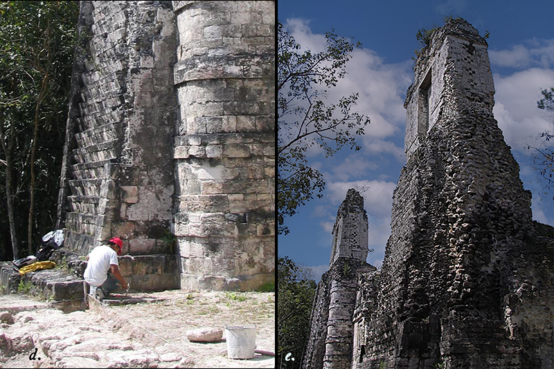
Genuine Petén-style vs Pseudo Río Bec-style Pyramids
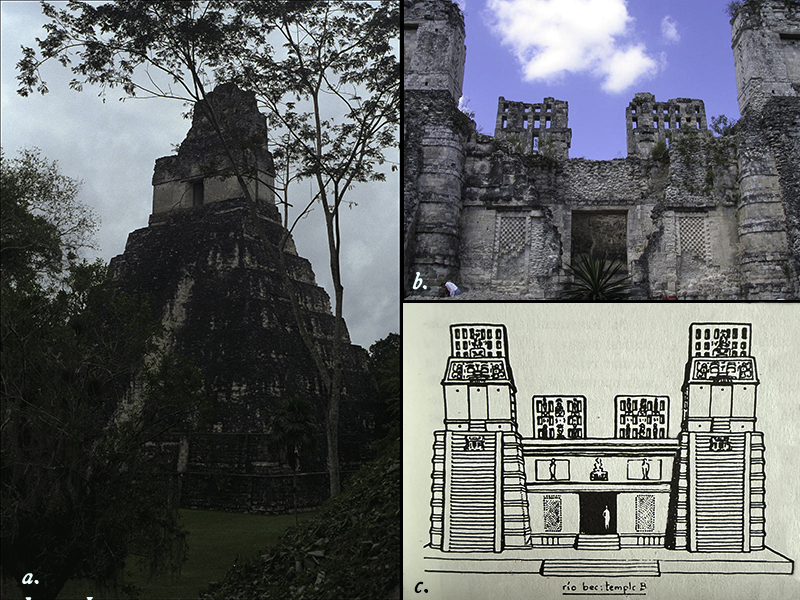
a) Tikal Temple I, a Classic Period Petén-style pyramid contemporaneous with Río Bec B.
b) Río Bec B showing central low building and portions of its fake pyramid-temples.
c) Paul Gendrop's reconstructive diagram of Río Bec B.
d) The non-functional and impossibly steep central stair of false pyramid.
e) The exaggerated towers and non-functional monster-mouth temples adorning Río Bec B.
Architecture of rural Río Bec
Rio Bec architecture seems to evoke extreme and opposite reactions from scholars. Michael Coe, calling the Río Bec towers an ‘aberrant architectural style,’ writes:
Here showiness rather than function is what was apparently sought, for characteristic of this style of the Late Classic is the decoration of perfectly ordinary small ‘palaces’ with high towers imitating the fronts of temple-pyramids. It is as though the Rio Bec architects wished to imitate the great Tikal temples without going to any trouble.
Michael D. Coe, "The Maya", p.112-3
Paul Gendrop, the art historian, is more sympathetic, noting that Tikal was building its most impressive temples at precisely the same time as the Río Bec pseudo-temples were being constructed. He writes:
In the prehispanic Mesoamerican world, public manifestations of worship were made outdoors, essentially. In order to support the weight of a constantly more impressive roofcomb, the “holy of holies” had been reduced to truly absurd proportions, as in the case of Temple V at Tikal. We might conclude that—at least in regard to some of the gigantic temple-pyramids in the Petén—the ceremonial requirements eventually could get along with just the physical and symbolic presence of the sanctuary whose inner space had become practically useless.
From uselessness to complete suppression was merely a step, and this is what probably took place north of the Petén in the ceremonial centers of Río Bec, where the only thing preserved, though scrupulously, was the exterior appearance of the temple-pyramid with its vital and inseparable addition of symbolic elements.
Paul Gendrop, Rio Bec, Chenes, and Puuc Styles in Maya Architecture, p. 35-36
Photos and more information about Río Bec sites is available on the MayaRuins website.
Xpujil, A Gateway City at the Crossroads
Photo from Google Maps
Xpuhil is located at the intersection of two major overland trade routes which traversed the Yucatan north/south and east/west. It, like Becán, is located on the elevated ridge running east-west across the Yucatan Peninsula which Highway 186 now follows, while the north-south passage connected the old Petén kingdoms like Tikal and Calakmul with the newly rising, wealthy agricultural centers of the Chenes and Puuc regions to the north is where Highway 269 runs today. The point of intersection is the Xpujil Aguada, a large and human-enhanced water hole where travelers could restock on water and refresh their supplies. This water hole accounts for why the two most important overland trade routes intersected here, and gives justification for the placement of the city of Xpujil itself.
Xpujil likely operated as an administrative sub-center within Becán’s immediate sphere of influence during the period of Calakmul’s oversight, but came into its own during the construction boom following the defeat of Calakmul. Xpujil served as a resupply center for travelers along the trade routes, as a marketplace for the exchange of goods both local and imported, as a local ritual and religious center, and as the gateway to Becán, the ancient administrative center of the region.
Xpujil Str I Faces East along the East/West trade route
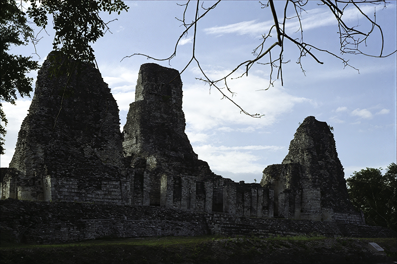
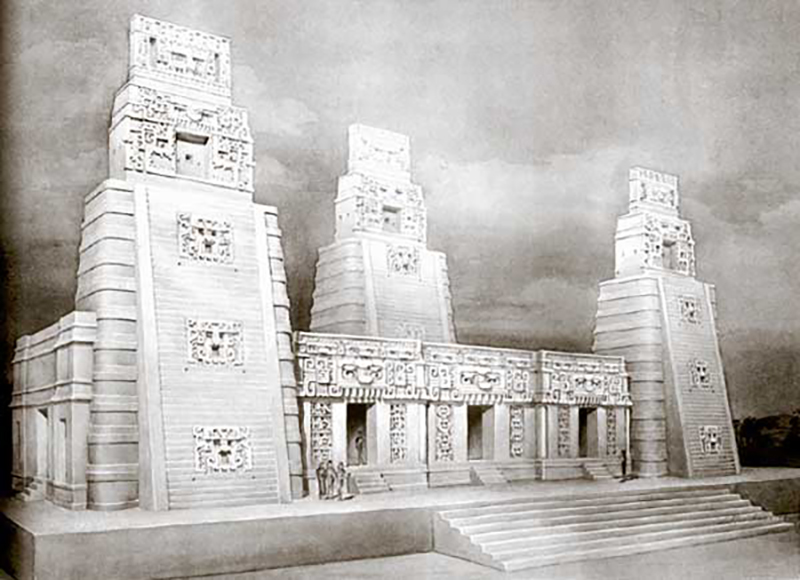
1996 photo of Xpujil Structure I, with Tatiana Proskouriakoff’s reconstructive drawing below
Xpujil’s Structure I sits astride the east-west overland trade route that crosses the base of the Yucatan Peninsula, its towers facing east like a giant billboard advertising its presence. Structure I is a classic example of the new “Río Bec” construction: a low palace-like rectangular building bracketed by pseudo-pyramids topped with pseudo “monster-mouth” temples. Structure I is unusual, however, because the third, central tower gestures backwards toward Becán, directly to the west. The third tower, interestingly, is taller than the north and south towers, as noted by Ruppert & Dennison of the Carnegie Expedition when they visited in 1942.
Rear of Str I Central Tower
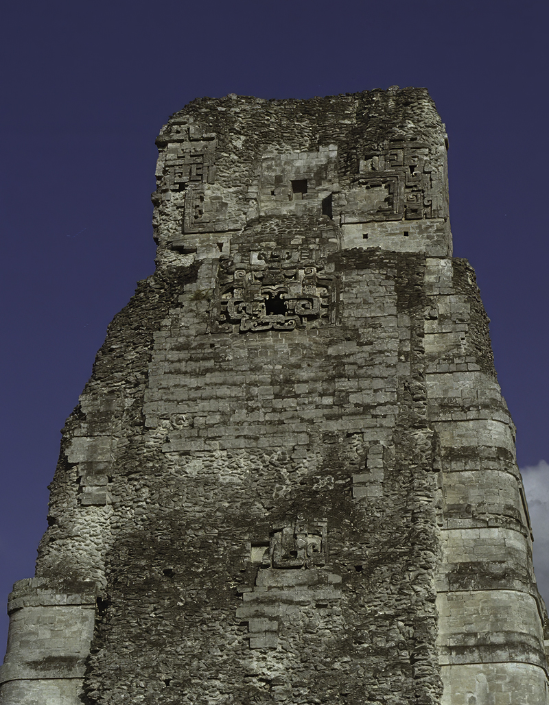
This photo illustrates the use of a thin veneer of well-finished stones attached to a core of rubble bound by lime mortar, which enabled the attachment of finely detailed ornamentation as well as lightened the overall weight of the building and permitted the inclusion of interior passages and stairways. This new technology also greatly reduced the labor and cost of new buildings.
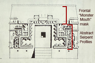
The pseudo-temple crowning the central tower has lost much of its detail, but luckily Paul Genrop’s reconstructive drawing gives some idea of how is must have originally looked.
Paul Gendrop, Río Bec, Chenes, and Puuc Styles in Maya Architecture, Labyrinthos Press, 1998, p. 98
A beautiful feline mask decorates the top of the tower directly below the pseudo-temple. Originally, there were three such masks, the partial remains of the central mask barely visible in the lower portion of the photo. It was the development of the new construction techniques mentioned previously which made possible the tenoning of such detailed mosaic elements to the exterior of buildings and provided the foundation for the baroque exuberance of Río Bec architectural ornamentation.
West Tower: Interior Stairway to Roof
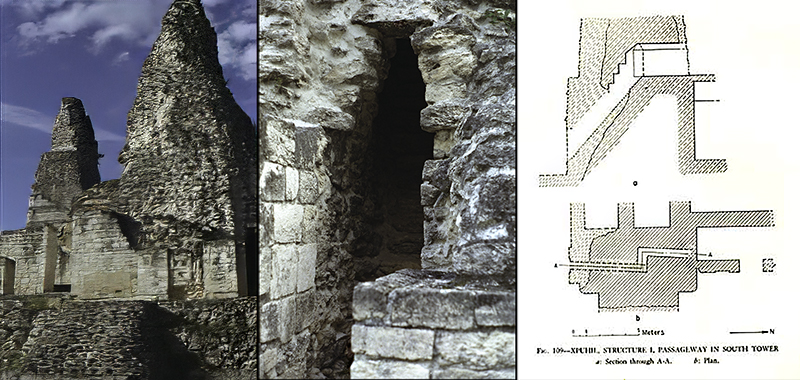
West Tower showing stair entrance on extreme right of photo; detail of entrance to stair; Ruppert & Dennisons diagram of interior passage
As mentioned in the Becán section, the new veneer and rubble construction techniques enabled interior passages and stairways to be built inside of these solid-looking towers. Such is the case of Structure I’s west tower, which has an interior stairway leading to the roof.

Ruppert & Dennison provided the diagram above, as well as a description of their exploration of the interior stairway:
“The south tower contains a passageway with portions of the upper part intact. Presumably one entrance was in a plain inset panel of the first zone of the south side whence a stairway led upward to the level of the roof of the building.
Five of the final upper risers are intact. From the top of the series of steps the passage extends horizontally westward 1.28 m., then northward 3.45 m. to the margins of the fallen masonry (pl. 40a); this portion is vaulted. The passageway had no doubt continued 70 cm. farther to open onto the roof of Room 1 (fig. 109). No indications of a passage were seen in either of the other towers.”
Photo insert from Ruppert, Karl & John H. Denison, Jr. Archaeological Reconnaissance in Campeche, Quintana Roo, & Peten. Publication 543. Washington D.C. Carnegie Institution of Washington. 1943, p. 87
Internal stair to roof performance area
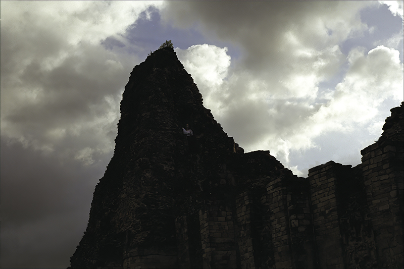
Me, at Structure I in 1997. Photo courtesy of Marion Canavan
When we visited in 1997, I (perhaps foolishly) climbed this internal stairway. It was dark and narrow and claustrophobic, and many of the steps were missing, but as the upper photo attests, I eventually made it to the top. Similar internal stairways have been found in Río Bec A, which convinces me that these stairways were an important feature of the towers and served as stage doors onto performance areas on the roof; thus the elevated area between the towers could serve as the perfect elevated stage for rituals and dance performances.
Chicanná: Elite Suburb of Becán
Located just a few kilometers from Becán and built during the architectural flowering following the demise of Calakmul, Chicanná was an elite residential enclave and royal retreat constructed for Becán’s newly independent ruling class. It features some of the most intricate zoomorphic monster-mouth temples and served as a stage for high-level, exclusive rituals rather than mass public spectacles.
David Stuart, in his “The Four Heavens: A New History of the Ancient Maya,” writes:
There is little historical context for these sites in the late eighth century, but I am intrigued that so many in southern and central Campeche have buildings that emphasize serpents in their facade decoration. Some of the so-called Chenes style, overlapping temporally with Rio Bec, exhibit central doorways that are the form of an open serpent mouth, where one enters through the open maw of a snake. The development of these serpent buildings in a region between Dzibanche and Calakmul, the major political seats of the Kanul [Snake Kingdom], suggests a connection to that storied dynasty.
Monster Mouth Temples
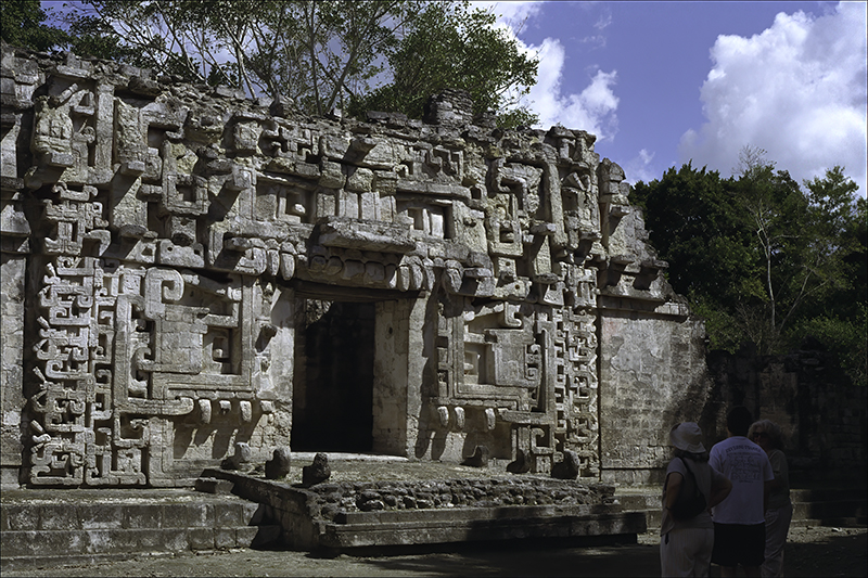
The same engineering shift taking place across the region was also the exact technology required to build the spectacular Witz (earth monster) portals, whose gaping reptilian jaws echoed the serpent iconography of the Kanul dynasty. You cannot easily carve intricate, cascading serpent jaws out of massive, load-bearing structural blocks—the weight distribution makes it prone to collapse. But by using small, modular veneer stones set into a mortar core, the architects could treat the building’s facade like a 3D stone mosaic. They could carve individual fangs, eyes, and snouts onto small blocks on the ground, and then assemble the monster piece-by-piece on the wall. Core-veneer masonry was the essential engineering breakthrough that allowed the construction of these hyper-detailed religious facades on a regional budget.
The Iconography of the Snake
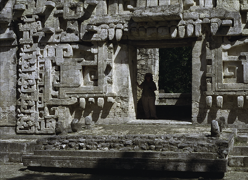
Abstract and conventionalized open-jawed profile serpent heads bracket each side of the door of the temple. In addition, a stack of four highly abstracted profile serpent heads form the almost fractal iteration of the theme that borders the whole composition. The short stair and platform leading to the temple door represents the lower jaw of the snake, complete with teeth arrayed on each side.
)
The Celestial serpent enters the temple
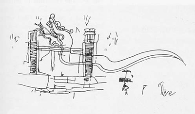
Chan in Maya has the double meaning of both snake and sky, and the iconography of the creator god Itzamná plays on this double meaning. Graffiti found in the central room of Structure II at Chicanná, as it was in 1972, shows this sky-serpent entering the temple.
Paul Gendrop, Rio Bec, Chenes, and Puuc Styles in Maya Architecture, p. 35
More photos & commentary on Chicanná is found on the MayaRuins website.
Hormiguero
The monster-mouth temple at Hormiguero has been called “the most wildly theatrical of all the Río Bec buildings.” Paul Gendrop, the art historian, remarks that the heroic dimensions of this temple, dedicated to the creator god Itzamná, “reaches the sphere of mythical surrealism” and refers to its “powerful and disquieting fascination”.
Located in the agricultural hinterlands of the south, Hormiguero represents the apex of the rural estate model—a private, decentralized manor so wealthy it could afford to build multiple fully realized Chenes-style monster-mouth portals in addition to the gigantic Structure II, a Río Bec fusion of a zoomorphic temple book-ended by oversized Río Bec pseudo-pyramids.
Structure II

The Instituto Nacional de Antropología e Historia de México‘s website, called Lugares INAH, has a spectacular drone Hormiguero flyover video. Be sure to use the forward/back arrows in the picture area for building closeups. Photo by Jeff Purcell, January 5, 2003
One enters Structure II through the menacing serpent jaws of the creator god Itzamná. Structure II, the principal temple at Hormiguero, is dedicated to Itzamná in his reptilian incarnation.
Upon gazing at these gigantic menacing jaws we can recall one of the invocations of Itzamná as Hapaycán: “the serpent that imbibes or swallows.” And if, to our Western eyes, this recalls some Dantean vision of hell, it must have been for the Mayas of the time a poetic and stimulating sign of life and hope. George Kubler speaks of the possible “descent of the celestial monster into the interior of the temple, bringing with it benefits from the beyond.”
Thus, under this monstrous appearance, which goes far beyond the merely three-dimensional—the earthly—to reach a sphere of mythical surrealism, the multiple facets of the creator deity unfold simultaneously before our eyes, with its powerful collection of symbols both celestial and terrestrial—stars, rain, new vegetation, life and death—which fuse here in an especially subduing apparition.
Paul Gendrop. Rio Bec, Chenes, & Puuc Styles in Maya Architecture. Labyrinthos Press. Lancaster, California 1998, p. 72
Str II as it was in 1933


Top: Ruppert, Karl & John H. Denison, Jr. Archaeological Reconnaissance in Campeche, Quintana Roo,& Peten. Publication 543. Washington D.C. Carnegie Institution of Washington. 1943, plate 11a
Bottom: Ricardo Cosio’s reconstruction of how Structure II might have once looked: Gendrop, Paul. Rio Bec, Chenes, & Puuc Styles in Maya Architecture. Labyrinthos Press. Lancaster, California 1998, p. 57-59
The massive scale of Structure II and its oversized towers is best captured in this 1933 photo, while Ricardo Cosio’s reconstructive drawing fills in details of how the original building might have looked.
Gorgeous masks on the tower wings
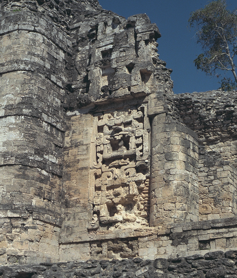
Gorgeous feline mask stacks decorate the outer wings of Structure II. This photo is to the right of the central doorway.
Note: More photos and commentary on Hormiguero can be found on the MayaRuins website.
Conclusions
The new core-and-veneer architectural techniques developed in the Río Bec/Chenes region after the demise of Calakmul made possible the wildly baroque architectural ornamentation and abstract surface patterning which characterizes this tradition. Buildings were now highly decorated and extravagantly theatrical, yet did not require the massive manpower—or the social control—required to organize construction on a massive scale. Building became less costly and within reach of even the dispersed rural landowners scattered about the countryside.
The building itself replaced the stela as the primary canvas for conveying status. The urban aristocrats and wealthy landowners of the Río Bec left no carved monuments recording their names, their pedigrees, or their conquests. Everything we know about these lords of the hinterlands must be read from their elaborate iconography, the theatricality of their designs, and the sheer fantasy of their facades.
This lack of militaristic monuments marks a profound shift in how the Río Bec elite justified themselves. In the old jungle kingdoms of Tikal and Calakmul, kings projected power by erecting massive stelae depicting bound captives and celebrating bloody conquests. In the Río Bec, however, power was projected through wealth and cosmic validation. Instead of conquering their neighbors, these wealthy landowners poured their resources into transforming their estates, thereby validating their authority through wildly theatrical architecture rather than endless Petén-style warfare.
Comments? Questions? Let us know at newsletter@mayaruins.com
Our AUG/SEP 2026 Issue, “The Puuc Vocabulary of Power, ” examines how Lord Chac of Uxmal used a combination of Water Snakes/Chac rain god images to project his power as the controller of rains.
NOTE: Visit our ARCHIVE for past newsletters.