If you missed the earlier newsletters in the El Mirador series, they are available online in our Insights Archive.
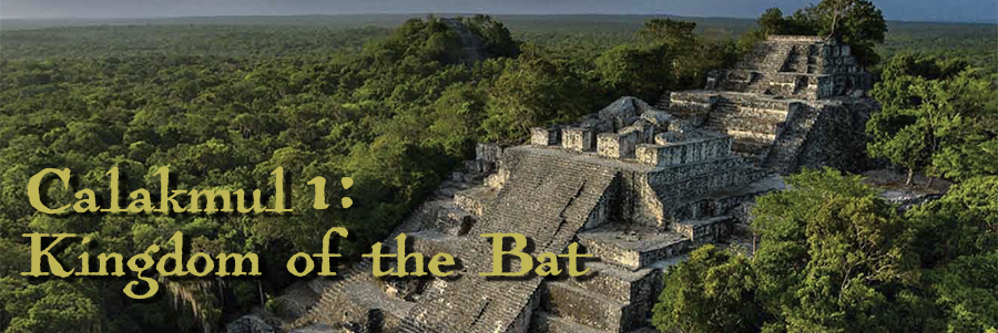
Preclassic Calakmul
Calakmul is located at the northern boundary of what is known as the Mirador-Calakmul Karst Basin. During the Late Preclassic (400 BC–150 AD), it was connected to El Mirador and the other cities of the Basin by causeways (sacbé) and participated in the culture of what appears to have been a Mirador Basin superstate. This is the area where Maya civilization took form and where the inhospitable geography of the Basin was key in shaping Maya city planning, Maya politics, and Maya religion.
The Mirador Basin, formed when seafloors were pushed up by the action of tectonic plates, is a landscape built on porous limestone and characterized by underground rivers, subterranean caves, hilly outcroppings, and a water table inaccessible through surface drilling. Bajos or stagnant seasonal swamps formed in natural depressions. It was a challenging landscape where lack of water was a perpetual problem during the long dry season and especially urgent in years of drought.
When the agricultural bajos silted up and cities of the Preclassic Mirador Basin collapsed around 150 AD, Calakmul managed to survive and prosper, partially because it had successfully solved its water problem. By organizing massive engineering forces, it transformed the pyramids and plazas of the city into gigantic funnels which channeled rainy season water into storage reservoirs for use in the dry season.
Vernon Scarborough has categorized ancient water management in this area into two contrasting models: the Mirador Basin's concave water management model, where swampy wetland depressions (bajos) supported a chinampas agricultural system as seen in El Mirador , and the convex model adopted by Calakmul and it great rival Tikal, where reservoirs and aguadas carved out of the elevated areas of the civic center controlled the flow of stored rainy-season water. This engineered hydraulic system was owned and controlled by powerful “Water Kings” who built and managed the massive water collection infrastructure.
Formal quarrying activities were a planned process in the construction of a center, with the location of quarry fill and the depression that resulted a deliberate act, possibly as important to the built environment as the pyramids themselves. It was the conversion of these depressions into tanks and formal reservoirs that provided the water necessary for both the construction of the center as well as its maintenance. The first order of business at a Maya construction site was the excavation of a tank system. In most cases, the location of the elevated tanks was in immediate proximity and below the most grand construction projects at a site.
Vernon L. Scarborough, Ecology and Ritual: Water Management and the Maya, Latin American Antiquity, Vol. 9, No 2 (June 1998), pp. 135-159. Available online at JSTOR
In this way, the “convex” Calakmul model turned the city itself into an elevated artificial watershed through human terraforming.
Calakmul Hydraulic Works
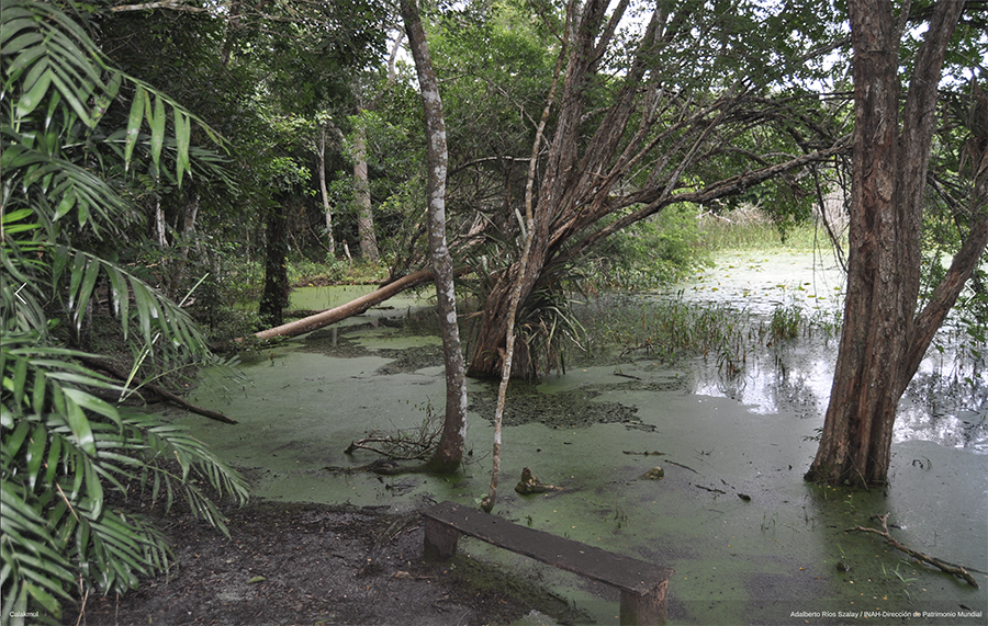
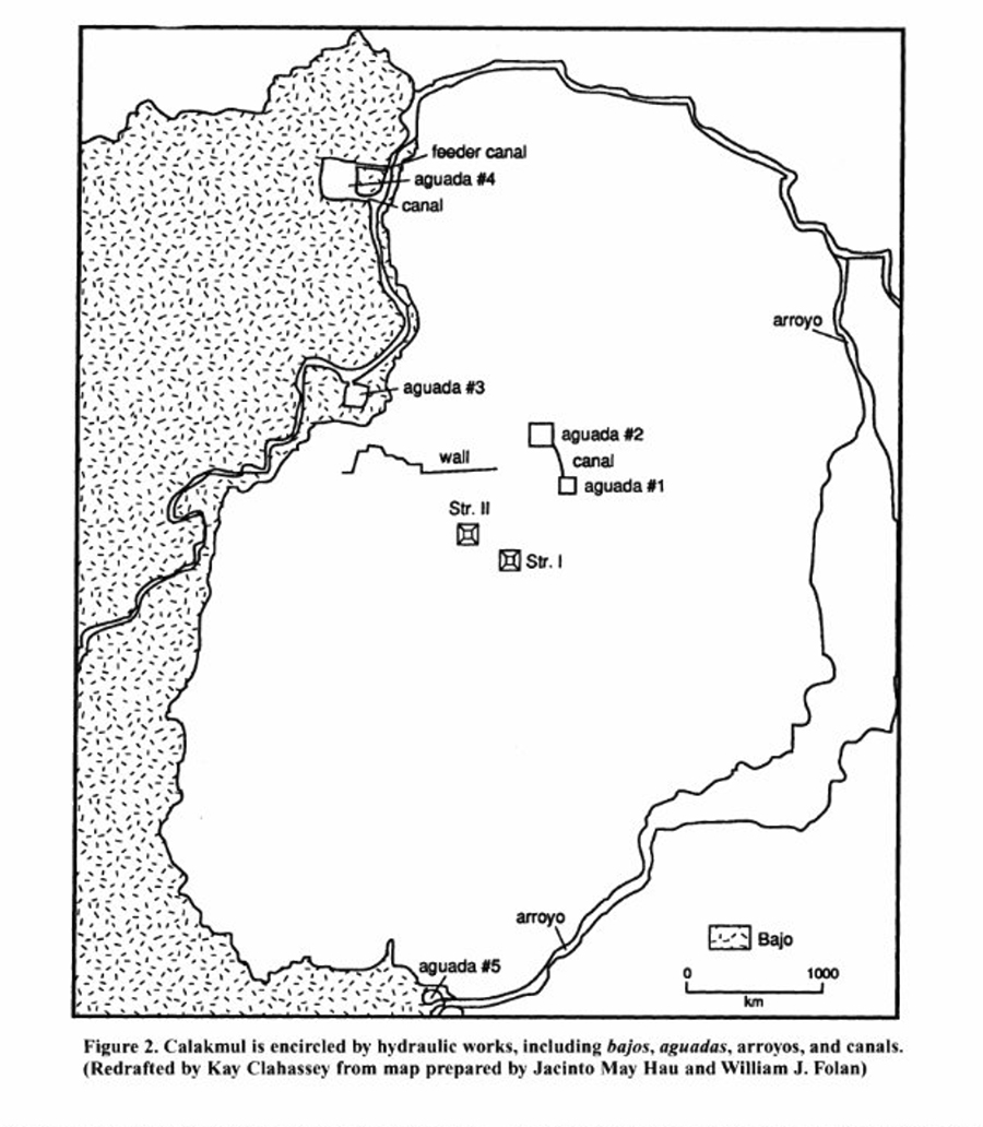
Photo: Instituto Nacional de Antropología e Historia used under the Creative Commons BY-NC-ND 4.0 license. Diagram of Calakmul Hydraulic Works: New Data from an Ancient Maya Capital in Campeche, Mexico, Wm. Folan et al, Cambridge University Press, “Latin American Antiquity”, Dec., 1995, Vol. 6, No. 4 (Dec., 1995), pp. 310-334
Calakmul had 13 massive reservoirs built within the city, lined with stucco to make them waterproof and interconnected through a system of canals. Rainy season water was funneled from urban pyramids and their sloped stuccoed plazas into this water catchment and distribution system, which was controlled by an extensive system of dams, canals, and sluice gates—and was powered by the force of gravity. Although today Calakmul's reservoirs, aguadas and canals are obscured after the neglect and silting of thousands of years, they are still visible to those who look.
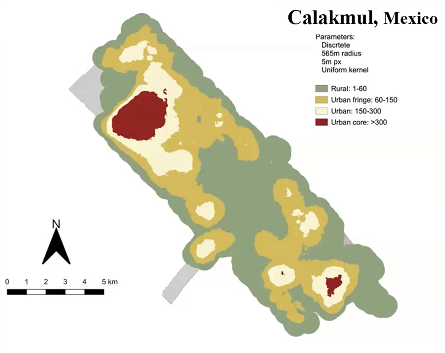
Calakmul Population Heat Map
Talk at the PreColumbian Society of the University of Pennsylvania Museum, September 13, 2025. Drs. Arlen F. Chase and Diane Z. Chase (University of Houston), “I Did It My Way: Variation between the Ancient Maya of Caracol and their Contemporaries."
Recent LiDAR data has significantly increased the estimates of ancient Maya population densities. It is astonishing to me that the central Maya lowlands were once able to support vastly greater populations during the Preclassic and Classic periods than is possible today.
These populations were made possible because of the highly engineered environment—the hydraulic engineering and networks of elevated causeways which doubled as dams to control water flow—created by a complex society and overseen by powerful kings.
Ancient vs. Modern Population Densities
Late Preclassic (300 BCE–150 CE) ~50–100 persons/km²
Regional: ~1,000,000 (Mirador Basin alone during Late Preclassic)
Late Classic (600–900 CE) ~80–120 persons/km²
Regional average: 9.5–16.5 Million in entire Maya Lowlands
Modern (2025–2026) ~15–25 persons/km²
Modern Petén/Interior: ~600,000 (Petén Department)
Lyons EC, Turner BL. On the absence of a millennial population rebound in the central Maya lowlands. Ancient Mesoamerica. 2025;36(1):106-122.
These massive populations in the Late Preclassic and Late Classic were supported by urban construction built centuries earlier in the Preclassic: massive pyramids and broad plazas, with the associated quarries which became water-collection reservoirs.
Middle Preclassic (ca. 400 BC - 300 BC)
Recent excavations and LiDAR data show that the city's monumental urban plan was largely established between 550 BC and 300 BC. The map below shows structures which have been identified as having Preclassic cores highlighted in green [however, since the Maya built on top of previous structures, it is sometimes impossible to identify which have Preclassic cores other than by tunneling]. Of course, in addition to the pyramids and plazas, the reservoirs and arroyos were also in place by this time.
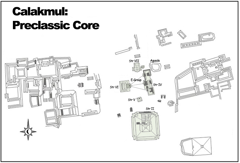
The central north-south oriented Grand Plaza is the oldest part of Calakmul. Besides having religious functions, these structures also housed rich tombs. Structure VII/VIII is a triadic pyramid typical of those seen elsewhere in the Mirador Basin. Structure VI and IV compose an E-Group, a kind of astronomical observatory used to mark the solstices and equinoxes and common to Preclassic sites.
Most significant, however, is Structure II, the gigantic Preclassic triadic pyramid which anchors the southern end of Calakmul’s Preclassic core and dominates the site.
Structure II
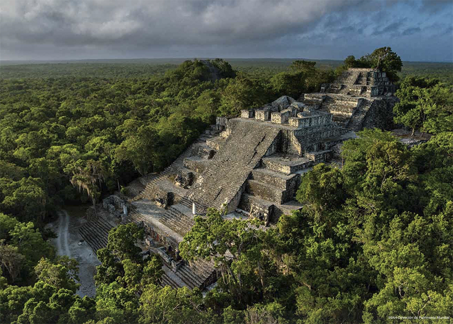
Structure II is one of the largest pyramids in Pre-Hispanic America. Most of its bulk dates from Preclassic, with a thin Classic veneer added during Late Classic times. It is similar in size and construction to the great contemporaneous El Tigre pyramid at El Mirador.
To the Maya, the pyramid itself—the “Water Mountain”—became a primary religious symbol. Because the water table was inaccessible through surface drilling, rain water had to be collected from above and funneled into reservoirs adjacent to the Water Mountain. Thus the pyramid was a literal and figurative source of life in a water-blind landscape.
The Ritualization of Water
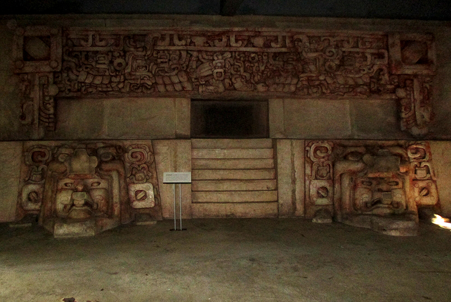
August Dominus, CC BY-SA 4.0 via Wikimedia Commons, Replica of Substructure II-C at Calakmul Site Museum
This Late Preclassic temple (ca. 100 BC—AD 150) was found buried within massive Structure II’s later Classic construction. The frieze portrays the rain god Chac accompanied by swirls of wind and the thunder & lightning of the Yucatecan rainy season. The temple doorway is a symbolic cave within the fertile Water Mountain of Maya mythology where the Maize God is reborn.
The typical Pre-Classic masks flanking the stair portray the Maize God emerging from the maw of the earth monster or Witz Mountain. Because this was a land where rivers flowed underground and carved caves into the surrounding limestone, Maya mythology reflected how the rebirth of the Maize God is dependent on water from the underworld. This world view thus explains why the temple doorway is in the form of a “symbolic cave.”
The Watery Underworld
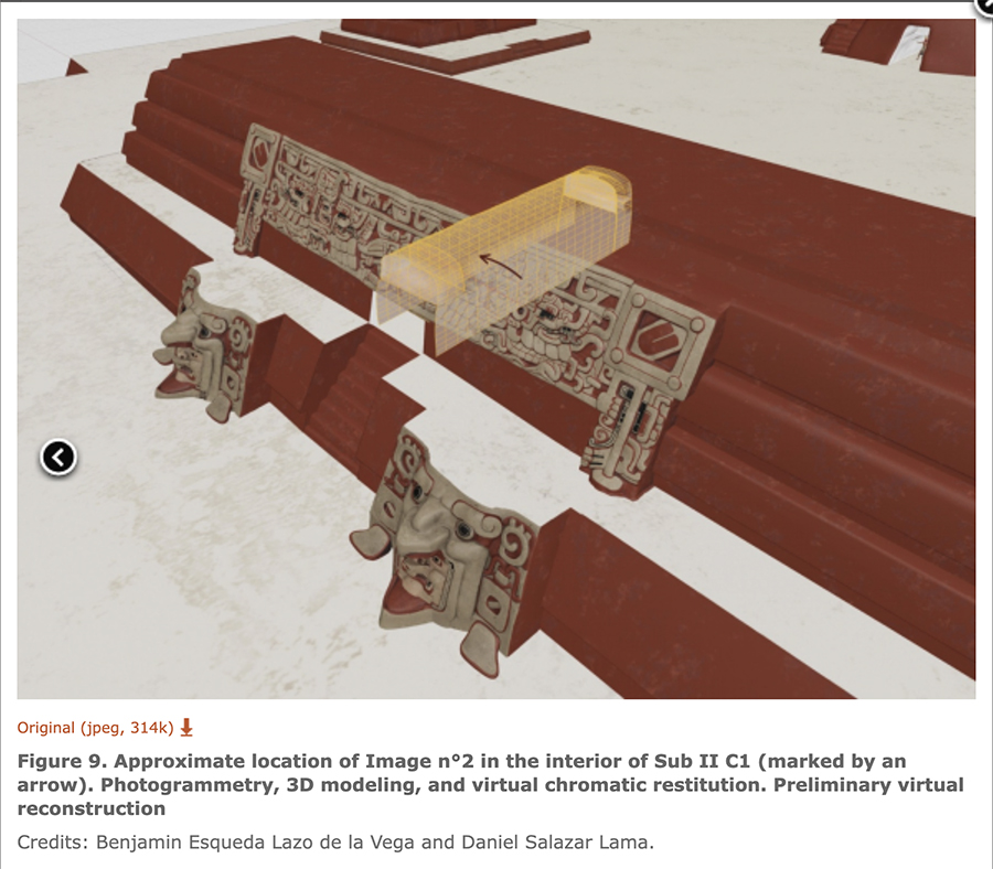
The yellow tunnel into the pyramid indicates the symbolic cave constructed in the heart of the pyramid-mountain. The arrow marks the location of the “Lord of the Spear” drawing which will be discussed next.
In the porous karst of the Mirador Basin, where rain quickly vanishes into the limestone, the Maya conceptualized the underworld, Xibalba, as a primordial, watery realm. This was not merely a place of death, but the subterranean source of all fertility. Because the physical water table was hidden deep beneath the surface, caves became ritually significant portals to the life-giving abyss.
The “architectural caves” within Structure II were human-made imitations of natural karst features. By constructing these tunnels, the Maya elite created a controlled environment where they could interact with the watery underworld, physically manifesting the belief that their "Water Mountain" (the pyramid) was anchored in the waters of the deep underground.
Drawing of Lord of the Spear, Hunahpu
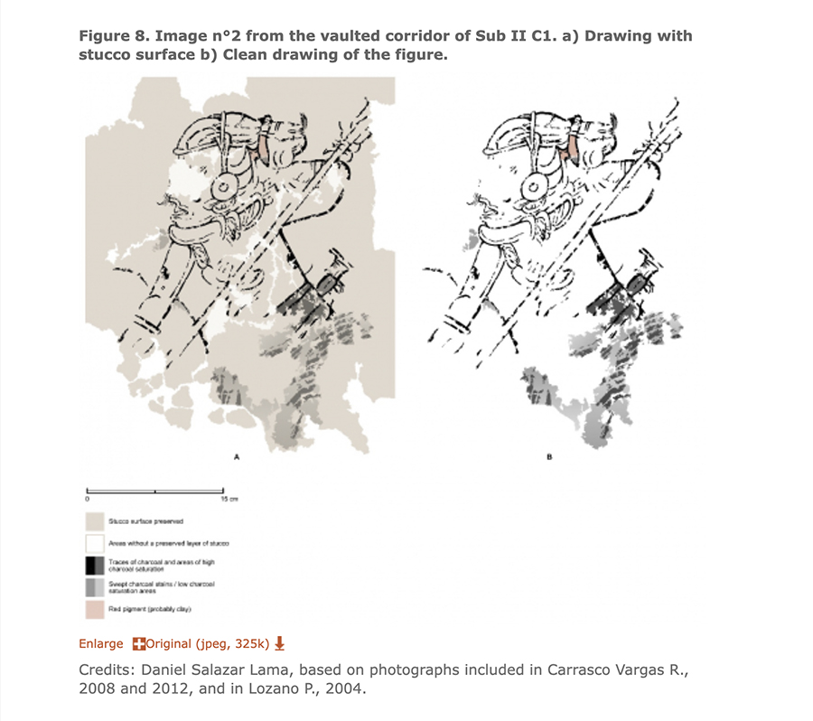
The placement of a drawing of The Lord of the Spear (Hunahpu, one of the Hero Twins) within these architectural caves is highly symbolic. In the Popol Vuh, the Hero Twins must journey into the watery depths of Xibalba to resurrect their father, the Maize God. By placing this imagery within the interior of the pyramid, Maya architects were replicating the sacred geography of the karst landscape, transforming a limestone pyramid into a functional bridge between the human and divine realms:
Other elements in the image suggest new interpretative possibilities, such as the succession of curved dark and thick lines over a light grey area [see above image]...They are found below Juun Ajaw [Hunahpu] and could be the reason why we cannot see the figure’s legs and the element at which the spear is directed. We note that this stain-like pattern is similar to that observed on some Late Classic Codex style pottery. On vessels K4013 and K521, similar sweeping lines or dark areas depict moving water or humid environments in the vicinity of mythological mountain-caves. Similarly, in a series of narrative images known as “confrontation scenes”, the representation of water employs an identical pictorial technique, with the bodies of the characters submerged to a depth of approximately half their height. If our observations are correct, the same could have happened with the character in Sub II C1, and he could have been covered with water up to his hips or thighs. Thus, the action that the personage performs with the spear could be taking place in a wet or watery space, which would make sense in the cavernous space in which he was represented.
At this time, the only available feature that supports our hypothesis is the slope of the corridor...the vaulted corridor of Sub II C1 connects the substructure inner courtyard with the main façade. During the 2022 field season, we observed a slight slope of the corridor to the north, directly to the second level main access. This led us to consider the possibility that during periods of heavy rainfall, the vaulted corridor of Sub II C1 may have channelled the water coming from the inner courtyard until it flowed through the main façade staircase, falling in a cascade below the frieze and the rain god Chaahk. If this is the case, the presence and actions of Juun Ajaw within the corridor would be contextualized in the context of a tangible aquatic environment of a cave. The potential outcome of this feature is to engage the observer with the environment and the scene in a phenomenological manner. This could be employed to create an immersive space within the vaulted corridor for the recreation or commemoration of a mythical narrative.
Daniel Salazar Lama, Ana García Barrios et Benjamín Esqueda Lazo De La Vega, The Lord of the Spear: New iconographic and contextual analysis of a parietal image in an architectural cave at Calakmul.
Transition to Early Classic (AD 250 to ~AD 550)
David Stuart, in his new book “The Four Heavens: A New History of the Ancient Maya,” argues that profound changes occurred in the way rulers were portrayed following the collapse of the Preclassic Calakmul-El Mirador Basin kingdoms:
Unlike the non-personal representations of the Preclassic, rulers were now moving front and center in the art, shown as agents on the cosmic stage. This ideology began to crystalize into a new and energetic idea of power adopted by many ruling lineages that coexisted throughout the central lowlands. The new idea of kingship was one of several political, demographic, and religious developments that we can begin to discern in the earliest detailed history.
David Stuart, The Four Heavens: A New History of the Ancient Maya. Princeton University Press, Princeton N.J, 2026, p. 101
This shift from the “non-personal” to the “personal” is visible in Maya art and architecture. If the Preclassic was defined by the massive, anonymous stucco masks of the Witz monster integrated into architecture, the Early Classic is defined by the individualized face of the K’uhul Ajaw (Holy Lord) crafted as death masks and deposited in tombs. The ruler no longer just served the mountain; he became the mountain’s living personification.
Funeral Headdress & mask
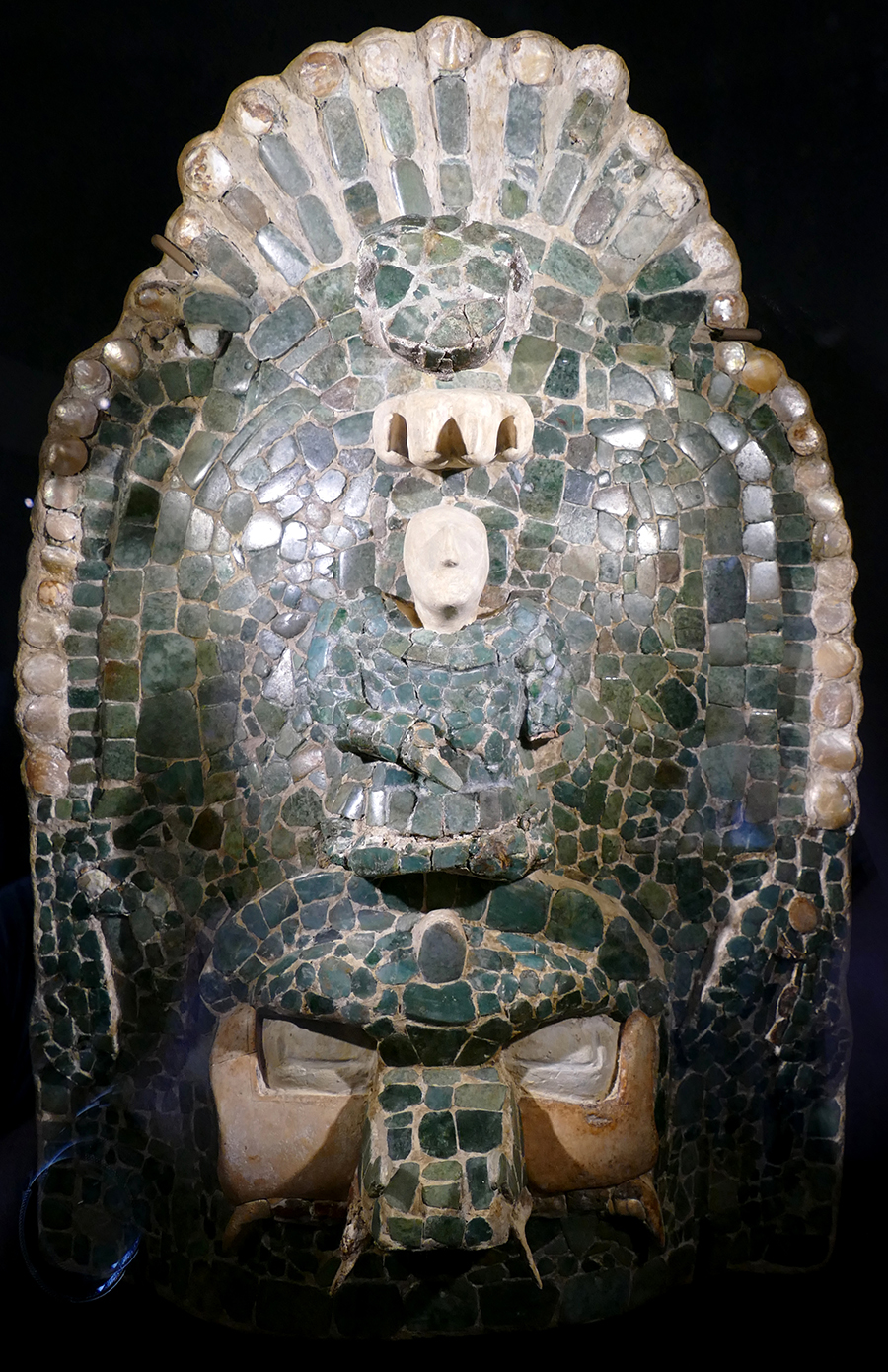
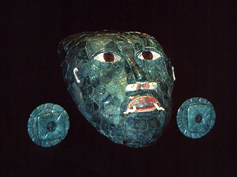
Lower photo courtesy of Louisa Spottswood. Upper photo: Bernard DUPONT - Museo Arqueológico Maya, Fuerte de San Miguel, Campeche, MEXICO. Used under Creative Commons CC BY license. See this article in Mesoweb for more information about the contents of this tomb.
The Early Classic ruler known as Long Lipped Jawbone (named for the distinct glyphic signature in his tomb) provides our first personal look at a Calakmul sovereign. Buried within Structure III of his residential palace, his remains were accompanied by a suite of jade regalia that transformed the man into a living icon. The name “Long Lipped Jawbone” is a nickname used by epigraphers to describe his name glyph, which features a prominent skeletal jaw and an elongated snout—a reference to a specific aspect of the Storm God.
The jade headdress in the upper photo is not just an ornament. In Maya iconography, the “Witz” (Mountain) is often depicted as a living entity with a cleft head—the same cleft from which the Maize God emerges. By wearing this headdress, the king is essentially “crowned” as the mountain itself. The jade funerary headdress found in Structure III thus serves as the theological missing link between his limestone pyramid and the human ruler himself:
- The Material of Abundance: Every plaque of the headdress is carved from jadeite, a stone the Maya equated with Ha (water), Ik (breath), and the green of the primary forest. To wear jade was to wrap oneself in the fertility of the rainy season.
- The Cleft of Creation: The headdress features the zoomorphic face of the Witz Monster. On its brow is the “sacred cleft,” a symbolic representation of the split in the mountain from which the first maize seeds sprouted. Some scholars even see the small white head emerging from the center of the mask as a representation of sprouting maize.
- The King as Provider of Water: By wearing the mountain as his headdress, the king became the source of water flowing through the city’s canals.
The use of jade was a deliberate theological choice. As a material, jade represented the essence of water, breath, and the green of the sprouting maize. By donning a jade mask and headdress, Long Lipped Jawbone was physically manifesting the Maize God—the same deity we see emerging from the Witz masks in the Preclassic. The king was now the “living portal” to the watery underworld.
The evolution of Portraits
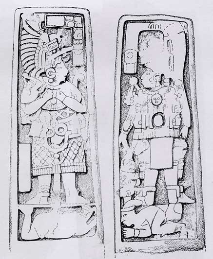
Drawings from Ruppert & Denison, Archaeological Reconnaissance in Campeche, Quintana Roo, and Peten, 1934: plate 49
As the Early Classic progressed into the 7th century, this “personalization” moved from the jade masks of the tomb to the public plazas. Stelae 28 and 29, dated to 623 AD, represent the culmination of this trend just before the arrival of the Snake Kings.
These monuments demonstrate a unique Calakmul hallmark: the paired portraiture of the King and his Queen. While their names are largely lost to time, their presence is undeniable. They stand atop bound prisoners—a stark departure from the religious abstractions of the Preclassic. This is political art in its purest form:
- Military Dominance: The “de rigueur” bound prisoner serves as a pedestal for royal authority.
- Dynastic Partnership: The inclusion of the Queen (Stela 28) suggests that matrimonial alliances may have played a central role in the statecraft of Calakmul.
- The “Snake” Absence: Crucially, these monuments do not yet bear the Kaanul (Snake) emblem. They represent the local “Ruler 2” and his consort, the final sovereigns of a regional dynasty before Calakmul became the seat of a pan-Maya empire.
While the rulers on Stelae 28 and 29 are depicted in the full regalia of the K’uhul Ajaw, they are effectively the final representatives of an independent Calakmul, the Kingdom of the Bat. Their monuments do not yet display the Kaanul “Snake” head emblem, which would soon become the most feared and respected symbol in the Maya world.
Our MAY 2026 Issue, “Calakmul: Kingdom of the Snake,” follows Calakmul after the arrival of the Snake Kings, who had their roots in the Preclassic royal dynasty from El Mirador. We will trace how, after a period of wandering, the Kaanul dynasty finally arrived in Calakmul and transformed the Kingdom of the Bat into a major superpower with webs of subordinate city-states spanning the region. We will also speculate on how the Snake Kings became locked in deadly conflict with their arch-enemy, Tikal, and thereby shaped the politics of the entire Maya Classic period.
Comments? Questions? Let us know at newsletter@mayaruins.com
NOTE: Visit our ARCHIVE for past newsletters.